
Geographic Region: UNITED ARAB EMIRATES
Feature: DUBAI, COAST, PALM ISLAND
|
Geographic Region: UNITED ARAB EMIRATES Feature: DUBAI, COAST, PALM ISLAND |
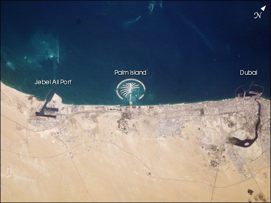 |
| Sometimes, what looks like a palm tree from orbit is, well, a palm tree. Palm Island Resort, just 1 mile off the coast from Dubai, is scheduled to be complete by 2006. Advertised as "being visible from the Moon" this man-made structure will have 17 huge fronds surrounded by a crescent-shaped breakwater. This island is being built from 80 million cubic meters (2.8 billion cubic feet) of land dredged from the approach channel to the Emirate's Jebel Ali port, which is being deepened to 17 meters (56 feet). Sediments in the water from dredging activity can be seen near the port. Palm Island is one of several massive projects in Dubai aimed at diversifying the economic base by expanding the tourist industry. The government of Dubai predicts that tourism, mostly from Europe, will quadruple to 15 million visitors annually by 2010. When completed the resort will have approximately 1200 single-family residences each with private beachfront, 600 multi-family residences, an aquatic theme park, shopping centers, cinemas, and more. A twin island is planned to be built nearby. |
| Images: | All Available Images Low-Resolution 37k |
|
| Mission: | ISS006 |
|
| Roll - Frame: | E - 35516 |
|
| Geographical Name: | UNITED ARAB EMIRATES |
|
| Features: | DUBAI, COAST, PALM ISLAND |
|
| Center Lat x Lon: | 25.0N x 55.0E |
|
| Film Exposure: | N=Normal exposure, U=Under exposed, O=Over exposed, F=out of Focus |
|
| Percentage of Cloud Cover-CLDP: | 10 |
|
| Camera:: | E4 |
|
| Camera Tilt: | 24 | LO=Low Oblique, HO=High Oblique, NV=Near Vertical |
| Camera Focal Length: | 180 |
|
| Nadir to Photo Center Direction: | NW | The direction from the nadir to the center point, N=North, S=South, E=East, W=West |
| Stereo?: | Y=Yes there is an adjacent picture of the same area, N=No there isn't |
|
| Orbit Number: | 480 |
|
| Date: | 20030305 | YYYYMMDD |
| Time: | 081046 | GMT HHMMSS |
| Nadir Lat: | 23.9N |
Latitude of suborbital point of spacecraft |
| Nadir Lon: | 56.1E |
Longitude of suborbital point of spacecraft |
| Sun Azimuth: | 172 | Clockwise angle in degrees from north to the sun measured at the nadir point |
| Space Craft Altitude: | 212 | nautical miles |
| Sun Elevation: | 60 | Angle in degrees between the horizon and the sun, measured at the nadir point |
| Land Views: | COAST, ISLAND |
|
| Water Views: | CHANNEL |
|
| Atmosphere Views: | |
|
| Man Made Views: | PORT, RESORT |
|
| City Views: | DUBAI |
|
Photo is not associated with any sequences | ||
| NASA Home Page |
JSC Home Page |
JSC Digital Image Collection |
Earth Science & Remote Sensing |
|
This service is provided by the International Space Station program and the JSC Earth Science & Remote Sensing Unit, ARES Division, Exploration Integration Science Directorate.

|