Geographic Region: DENMARK
Feature: PAN-JUTLAND PENINSULA, SCANDINAVIA
|
Geographic Region: DENMARK Feature: PAN-JUTLAND PENINSULA, SCANDINAVIA |
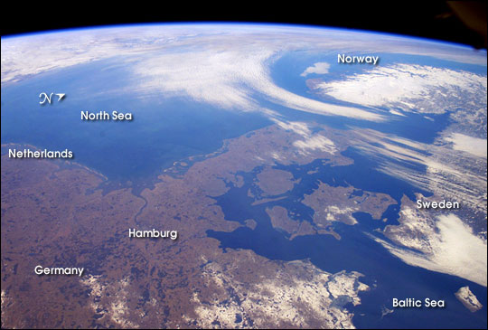 |
| The Kingdom of Denmark, with an area of 16,639 square miles, consists of the Jutland Peninsula and roughly 500 islands. It is also a part of the generally fertile and mostly agricultural region known as the North European Plain. This entire region is generally flat to slightly rolling and is overlain with deposits of Pleistocene glaciers. (The Pleistocene lasted from 1.8 million to 11,000 years ago, during which time several ice ages occured.) Taking advantage of remarkably fair weather over north central Europe for this time of year, the crew of the International Space Station took this panoramic view that extends from the North Sea coast of the Netherlands on the left to the Baltic Sea shores of Sweden on the right. The late-winter landscape has little snow cover except over northeastern Germany, Sweden, and the rugged mountains of Norway. Such images, composed by astronauts, provide unique, synoptic perspectives of the Earth's geography and natural processes. |
| Images: | All Available Images Low-Resolution 54k |
|
| Mission: | ISS006 |
|
| Roll - Frame: | E - 33901 |
|
| Geographical Name: | DENMARK |
|
| Features: | PAN-JUTLAND PENINSULA, SCANDINAVIA |
|
| Center Lat x Lon: | 56.0N x 9.0E |
|
| Film Exposure: | N=Normal exposure, U=Under exposed, O=Over exposed, F=out of Focus |
|
| Percentage of Cloud Cover-CLDP: | 25 |
|
| Camera:: | E4 |
|
| Camera Tilt: | HO | LO=Low Oblique, HO=High Oblique, NV=Near Vertical |
| Camera Focal Length: | 28 |
|
| Nadir to Photo Center Direction: | NW | The direction from the nadir to the center point, N=North, S=South, E=East, W=West |
| Stereo?: | Y=Yes there is an adjacent picture of the same area, N=No there isn't |
|
| Orbit Number: | 372 |
|
| Date: | 20030226 | YYYYMMDD |
| Time: | 094734 | GMT HHMMSS |
| Nadir Lat: | 51.5N |
Latitude of suborbital point of spacecraft |
| Nadir Lon: | 12.1E |
Longitude of suborbital point of spacecraft |
| Sun Azimuth: | 153 | Clockwise angle in degrees from north to the sun measured at the nadir point |
| Space Craft Altitude: | 211 | nautical miles |
| Sun Elevation: | 26 | Angle in degrees between the horizon and the sun, measured at the nadir point |
| Land Views: | COAST, PENINSULA, PLAIN |
|
| Water Views: | SEA |
|
| Atmosphere Views: | |
|
| Man Made Views: | |
|
| City Views: | |
|
Photo is not associated with any sequences | ||
| NASA Home Page |
JSC Home Page |
JSC Digital Image Collection |
Earth Science & Remote Sensing |
|
This service is provided by the International Space Station program and the JSC Earth Science & Remote Sensing Unit, ARES Division, Exploration Integration Science Directorate.

|