
Geographic Region: USA-ARIZONA
Feature: PAGE, GLEN CANYON DAM
|
Geographic Region: USA-ARIZONA Feature: PAGE, GLEN CANYON DAM |
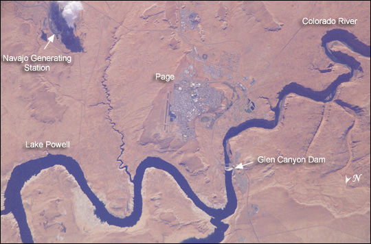 |
| This isolated community near the northern Arizona border is of special interest because of its origin and location. Unlike other towns in the area, Page was created in 1957 to house workers and their families during the construction of nearby Glen Canyon Dam on the Colorado River. Its 17-square-mile site was obtained in a land exchange with the Navajo Indian tribe. The town is perched atop Manson Mesa at an elevation of 4,300 feet above sea level and 600 feet above Lake Powell. After the dam was completed in the 1960s, the town grew steadily to today's population of 6,200. Because of the new roads and bridge built for use during construction, it has become the gateway to the Glen Canyon National Recreation Area and Lake Powell, attracting more than 3 million visitors per year. Page is also the home of two of the largest electrical generation units in the western United States. Glen Canyon Dam has a 1,288,000 kilowatts capacity when fully online. The other power plant to the southeast is the Navajo Generating Station, a coal-fired steam plant with an output capability of 2,250,000 kilowatts. |
| Images: | All Available Images Low-Resolution 81k |
|
| Mission: | ISS006 |
|
| Roll - Frame: | E - 28359 |
|
| Geographical Name: | USA-ARIZONA |
|
| Features: | PAGE, GLEN CANYON DAM |
|
| Center Lat x Lon: | 37.0N x 111.5W |
|
| Film Exposure: | N=Normal exposure, U=Under exposed, O=Over exposed, F=out of Focus |
|
| Percentage of Cloud Cover-CLDP: | 10 |
|
| Camera:: | E4 |
|
| Camera Tilt: | 21 | LO=Low Oblique, HO=High Oblique, NV=Near Vertical |
| Camera Focal Length: | 800 |
|
| Nadir to Photo Center Direction: | NE | The direction from the nadir to the center point, N=North, S=South, E=East, W=West |
| Stereo?: | Y=Yes there is an adjacent picture of the same area, N=No there isn't |
|
| Orbit Number: | 206 |
|
| Date: | 20030215 | YYYYMMDD |
| Time: | 180857 | GMT HHMMSS |
| Nadir Lat: | 36.1N |
Latitude of suborbital point of spacecraft |
| Nadir Lon: | 112.5W |
Longitude of suborbital point of spacecraft |
| Sun Azimuth: | 151 | Clockwise angle in degrees from north to the sun measured at the nadir point |
| Space Craft Altitude: | 213 | nautical miles |
| Sun Elevation: | 37 | Angle in degrees between the horizon and the sun, measured at the nadir point |
| Land Views: | |
|
| Water Views: | LAKE, RIVER |
|
| Atmosphere Views: | |
|
| Man Made Views: | DAM |
|
| City Views: | PAGE |
|
Photo is not associated with any sequences | ||
| NASA Home Page |
JSC Home Page |
JSC Digital Image Collection |
Earth Science & Remote Sensing |
|
This service is provided by the International Space Station program and the JSC Earth Science & Remote Sensing Unit, ARES Division, Exploration Integration Science Directorate.

|