
Geographic Region: ARGENTINA
Feature: BUENOS AIRES AT NIGHT
|
Geographic Region: ARGENTINA Feature: BUENOS AIRES AT NIGHT |
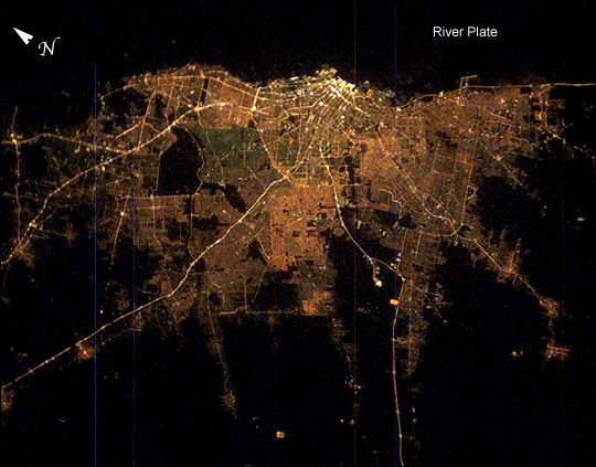 |
| Buenos Aires is one of the larger cities seen by orbiting crews. Twelve million people, almost one third of all Argentines, live in this city, often called the Paris of the South. Taken very early on the morning of Saturday, February 8, 2003, from the International Space Station with the handheld eclectronic still camera, this remarkably clear image shows the lights of Argentina's capital city. Brightness of the lights exactly represents the density of the urban population, which declines all the way to the blackness of the farmlands that surround the city. The brightest area is the old part of the city centered on the port and the presidential palace, the Casa Rosada. The blackest part of the scene is the River Plate, the great estuary of the Atlantic Ocean on which this port city is located. The widest city thoroughfare in the world--the Avenida 9 de Julio with four major roads running parallel, separated by grassy swards--is the brightest line in the downtown cluster. It appears as the longest north-south strip just inland of the port. Four major highways can be seen diverging from the city center. These highways may be more visible due to the well-known late-night traffic of weekend Buenos Aires. The inner part of Buenos Aires is the Federal Capital district, outlined by the great boulevard, Avenida General Paz. The straight segments of this boulevard angle around the north and west sides of the city. |
| Images: | All Available Images Low-Resolution 113k |
|
| Mission: | ISS006 |
|
| Roll - Frame: | E - 24987 |
|
| Geographical Name: | ARGENTINA |
|
| Features: | BUENOS AIRES AT NIGHT |
|
| Center Lat x Lon: | 34.5S x 58.5W |
|
| Film Exposure: | N=Normal exposure, U=Under exposed, O=Over exposed, F=out of Focus |
|
| Percentage of Cloud Cover-CLDP: | 10 |
|
| Camera:: | E4 |
|
| Camera Tilt: | 22 | LO=Low Oblique, HO=High Oblique, NV=Near Vertical |
| Camera Focal Length: | 58 |
|
| Nadir to Photo Center Direction: | SE | The direction from the nadir to the center point, N=North, S=South, E=East, W=West |
| Stereo?: | Y=Yes there is an adjacent picture of the same area, N=No there isn't |
|
| Orbit Number: | 88 |
|
| Date: | 20030208 | YYYYMMDD |
| Time: | 052357 | GMT HHMMSS |
| Nadir Lat: | 33.5S |
Latitude of suborbital point of spacecraft |
| Nadir Lon: | 59.5W |
Longitude of suborbital point of spacecraft |
| Sun Azimuth: | 158 | Clockwise angle in degrees from north to the sun measured at the nadir point |
| Space Craft Altitude: | 211 | nautical miles |
| Sun Elevation: | -39 | Angle in degrees between the horizon and the sun, measured at the nadir point |
| Land Views: | |
|
| Water Views: | ESTUARY, OCEAN, RIVER |
|
| Atmosphere Views: | |
|
| Man Made Views: | PORT |
|
| City Views: | BUENOS AIRES |
|
Photo is not associated with any sequences | ||
| NASA Home Page |
JSC Home Page |
JSC Digital Image Collection |
Earth Science & Remote Sensing |
|
This service is provided by the International Space Station program and the JSC Earth Science & Remote Sensing Unit, ARES Division, Exploration Integration Science Directorate.

|