
Geographic Region: USA-CALIFORNIA
Feature: OWENS LAKE,SIERRA NEVADA, LONE PINE
|
Geographic Region: USA-CALIFORNIA Feature: OWENS LAKE,SIERRA NEVADA, LONE PINE |
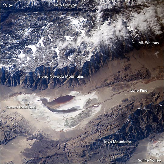 |
| Astronauts aboard the International Space Station looked obliquely down at the steep eastern flank of California's Sierra Nevada. Even from space the topography is impressive--the range drops nearly 11,000 feet from Mt. Whitney (under cloud, arrow), the highest mountain in the lower 48 states (14,494 ft), to the floor of Owens Valley (the elevation of the town of Lone Pine is 3,760 ft). The Sierra Nevada landscape is well known for deep, glacially scoured valleys, like Kern Canyon west of Mt. Whitney. The California landscape changes east of the Sierra, marked by alternating steep desert mountain ranges and valleys. Many of the valleys contain dry lakebeds, remnants of deep lakes that filled the valleys 11,000 years ago, at the end of the last ice age. Owens Lake was a salty lake until 1913, when the Owens River was diverted into the Los Angeles Aqueduct, quickly draining the lake. Today, Owens Lake is a dried salt flat that contains some pooled water following rains. Solar evaporation ponds lie along the northern edge. The bright red color in the wet parts of the lakebed is from the red color of salt-loving bacteria (halobacteria). |
| Images: | All Available Images Low-Resolution 94k |
|
| Mission: | ISS006 |
|
| Roll - Frame: | E - 24783 |
|
| Geographical Name: | USA-CALIFORNIA |
|
| Features: | OWENS LAKE,SIERRA NEVADA, LONE PINE |
|
| Center Lat x Lon: | 36.5N x 118W |
|
| Film Exposure: | N=Normal exposure, U=Under exposed, O=Over exposed, F=out of Focus |
|
| Percentage of Cloud Cover-CLDP: | 10 |
|
| Camera:: | E4 |
|
| Camera Tilt: | 51 | LO=Low Oblique, HO=High Oblique, NV=Near Vertical |
| Camera Focal Length: | 180 |
|
| Nadir to Photo Center Direction: | W | The direction from the nadir to the center point, N=North, S=South, E=East, W=West |
| Stereo?: | Y=Yes there is an adjacent picture of the same area, N=No there isn't |
|
| Orbit Number: | 68 |
|
| Date: | 20030206 | YYYYMMDD |
| Time: | 215502 | GMT HHMMSS |
| Nadir Lat: | 37.4N |
Latitude of suborbital point of spacecraft |
| Nadir Lon: | 113.9W |
Longitude of suborbital point of spacecraft |
| Sun Azimuth: | 215 | Clockwise angle in degrees from north to the sun measured at the nadir point |
| Space Craft Altitude: | 205 | nautical miles |
| Sun Elevation: | 30 | Angle in degrees between the horizon and the sun, measured at the nadir point |
| Land Views: | MOUNTAIN, RANGE, VALLEY |
|
| Water Views: | LAKE |
|
| Atmosphere Views: | |
|
| Man Made Views: | |
|
| City Views: | |
|
Photo is not associated with any sequences | ||
| NASA Home Page |
JSC Home Page |
JSC Digital Image Collection |
Earth Science & Remote Sensing |
|
This service is provided by the International Space Station program and the JSC Earth Science & Remote Sensing Unit, ARES Division, Exploration Integration Science Directorate.

|