Geographic Region: UK-ENGLAND
Feature: LONDON AT NIGHT
|
Geographic Region: UK-ENGLAND Feature: LONDON AT NIGHT |
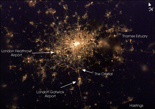 |
| Do you recognize this intriguing globular cluster of stars? It's actually the constellation of city lights surrounding London, England, planet Earth, as recorded with a digital camera from the International Space Station. Taken in February 2003, north is toward the top and slightly left in this nighttime view. The encircling "London Orbital" highway by-pass, the M25 (... but not Messier 25), is easiest to pick out south of the city. Even farther south are the lights of Gatwick airport and just inside the western (left hand) stretch of the Orbital is Heathrow. The darkened Thames river estuary fans out to the city's east. In particular, two small "dark nebulae" - Hyde Park and Regents Park - stand out slightly west of the densely packed lights at the city's core. The crew of the International Space Station acquired this image shortly after 7:22 p.m. local time on the evening of February 4, 2003. Either thin, low clouds or perhaps fog is evident in the fuzzy character of patterns for some of the surrounding smaller cities while that of the warmer urban center is still clear and sharp. |
| Images: | All Available Images Low-Resolution 53k |
|
| Mission: | ISS006 |
|
| Roll - Frame: | E - 22939 |
|
| Geographical Name: | UK-ENGLAND |
|
| Features: | LONDON AT NIGHT |
|
| Center Lat x Lon: | 51.5N x .0E |
|
| Film Exposure: | N=Normal exposure, U=Under exposed, O=Over exposed, F=out of Focus |
|
| Percentage of Cloud Cover-CLDP: | 0 |
|
| Camera:: | E4 |
|
| Camera Tilt: | HO | LO=Low Oblique, HO=High Oblique, NV=Near Vertical |
| Camera Focal Length: | 58 |
|
| Nadir to Photo Center Direction: | E | The direction from the nadir to the center point, N=North, S=South, E=East, W=West |
| Stereo?: | Y=Yes there is an adjacent picture of the same area, N=No there isn't |
|
| Orbit Number: | 35 |
|
| Date: | 20030204 | YYYYMMDD |
| Time: | 192210 | GMT HHMMSS |
| Nadir Lat: | 51.8N |
Latitude of suborbital point of spacecraft |
| Nadir Lon: | 7W |
Longitude of suborbital point of spacecraft |
| Sun Azimuth: | 268 | Clockwise angle in degrees from north to the sun measured at the nadir point |
| Space Craft Altitude: | 203 | nautical miles |
| Sun Elevation: | -19 | Angle in degrees between the horizon and the sun, measured at the nadir point |
| Land Views: | |
|
| Water Views: | ESTUARY |
|
| Atmosphere Views: | FOG |
|
| Man Made Views: | AIRPORT, HIGHWAY |
|
| City Views: | LONDON |
|
Photo is not associated with any sequences | ||
| NASA Home Page |
JSC Home Page |
JSC Digital Image Collection |
Earth Science & Remote Sensing |
|
This service is provided by the International Space Station program and the JSC Earth Science & Remote Sensing Unit, ARES Division, Exploration Integration Science Directorate.

|