Geographic Region: SOCIETY ISLANDS
Feature: HUAHINE, RAIATEA, BORA-BORA,TUPAI
|
Geographic Region: SOCIETY ISLANDS Feature: HUAHINE, RAIATEA, BORA-BORA,TUPAI |
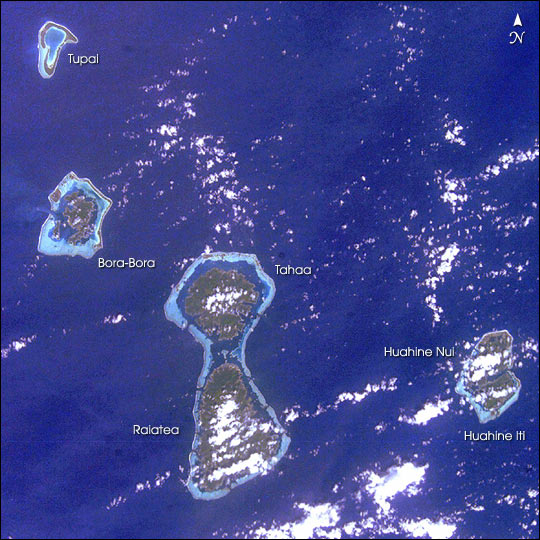 |
| In one frame International Space Station astronauts were able to capture the evolution of fringing reefs to atolls. As with the Hawaiian Islands, these volcanic hot spot islands become progressively older to the northwest. As these islands move away from their magma sources they erode and subside. The two large islands, Raiatea and Tahaa, share a single fringing reef. The next island to the northwest, Bora-Bora, consists of a highly eroded volcanic remnant with fringing reef. The last island, Tupai, signifies the destiny of these islands; the fringing reef has become an atoll with the central island below sea level. More information and photographs of tropical islands is included in the Islands chapter of Oceanography from the Space Shuttle (Links to this were removed because they no longer work). |
| Images: | All Available Images Low-Resolution 86k |
|
| Mission: | ISS006 |
|
| Roll - Frame: | E - 22132 |
|
| Geographical Name: | SOCIETY ISLANDS |
|
| Features: | HUAHINE, RAIATEA, BORA-BORA,TUPAI |
|
| Center Lat x Lon: | 16.5S x 151.5W |
|
| Film Exposure: | N=Normal exposure, U=Under exposed, O=Over exposed, F=out of Focus |
|
| Percentage of Cloud Cover-CLDP: | 25 |
|
| Camera:: | E4 |
|
| Camera Tilt: | 43 | LO=Low Oblique, HO=High Oblique, NV=Near Vertical |
| Camera Focal Length: | 85 |
|
| Nadir to Photo Center Direction: | E | The direction from the nadir to the center point, N=North, S=South, E=East, W=West |
| Stereo?: | Y=Yes there is an adjacent picture of the same area, N=No there isn't |
|
| Orbit Number: | 3990 |
|
| Date: | 20030201 | YYYYMMDD |
| Time: | 231449 | GMT HHMMSS |
| Nadir Lat: | 16.9S |
Latitude of suborbital point of spacecraft |
| Nadir Lon: | 154.8W |
Longitude of suborbital point of spacecraft |
| Sun Azimuth: | 267 | Clockwise angle in degrees from north to the sun measured at the nadir point |
| Space Craft Altitude: | 212 | nautical miles |
| Sun Elevation: | 80 | Angle in degrees between the horizon and the sun, measured at the nadir point |
| Land Views: | ATOLL, ISLAND |
|
| Water Views: | REEF |
|
| Atmosphere Views: | |
|
| Man Made Views: | |
|
| City Views: | |
|
Photo is not associated with any sequences | ||
| NASA Home Page |
JSC Home Page |
JSC Digital Image Collection |
Earth Science & Remote Sensing |
|
This service is provided by the International Space Station program and the JSC Earth Science & Remote Sensing Unit, ARES Division, Exploration Integration Science Directorate.

|