
Geographic Region: AUSTRALIA-NSW
Feature: BUSHFIRES, SMOKE
|
Geographic Region: AUSTRALIA-NSW Feature: BUSHFIRES, SMOKE |
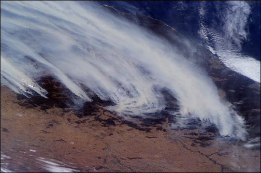 |
| For nearly six weeks now, southeastern Australia has been experiencing an unprecedented bushfire emergency. Following months of regional drought, the worst in 50 years, this summer's fire season has resulted in numerous large fires over much of the Great Dividing Range as well as an enormous smoke pall over New South Wales, Victoria, and the adjacent South Pacific Ocean. The fires have advanced from the lower foothills of the interior to higher elevations, recently threatening ski resorts in the Snowy Mountains. The crew of the International Space Station took this dramatic image of the fires on the morning of January 18, 2003. Brisk winds are sweeping smoke plumes eastward off the Australian coast north of Cape Howe. The agricultural valleys of the Murrumbidgee and Murray Rivers give way to the burning, darker bush areas of the mountains with the extreme eastern coastline of Victoria visible beyond. Images like these are a unique contribution to our understanding of dynamic events -- made possible by the human observer in orbit. |
| Images: | All Available Images Low-Resolution 73k |
|
| Mission: | ISS006 |
|
| Roll - Frame: | E - 19300 |
|
| Geographical Name: | AUSTRALIA-NSW |
|
| Features: | BUSHFIRES, SMOKE |
|
| Center Lat x Lon: | 36S x 148.5E |
|
| Film Exposure: | N=Normal exposure, U=Under exposed, O=Over exposed, F=out of Focus |
|
| Percentage of Cloud Cover-CLDP: | 25 |
|
| Camera:: | E4 |
|
| Camera Tilt: | LO | LO=Low Oblique, HO=High Oblique, NV=Near Vertical |
| Camera Focal Length: | 85 |
|
| Nadir to Photo Center Direction: | The direction from the nadir to the center point, N=North, S=South, E=East, W=West |
|
| Stereo?: | Y=Yes there is an adjacent picture of the same area, N=No there isn't |
|
| Orbit Number: | |
|
| Date: | 20030118 | YYYYMMDD |
| Time: | 00____ | GMT HHMMSS |
| Nadir Lat: | N |
Latitude of suborbital point of spacecraft |
| Nadir Lon: | E |
Longitude of suborbital point of spacecraft |
| Sun Azimuth: | Clockwise angle in degrees from north to the sun measured at the nadir point |
|
| Space Craft Altitude: | nautical miles |
|
| Sun Elevation: | Angle in degrees between the horizon and the sun, measured at the nadir point |
|
| Land Views: | COAST |
|
| Water Views: | |
|
| Atmosphere Views: | SMOKE, SMOKE PALL |
|
| Man Made Views: | |
|
| City Views: | |
|
Photo is not associated with any sequences | ||
| NASA Home Page |
JSC Home Page |
JSC Digital Image Collection |
Earth Science & Remote Sensing |
|
This service is provided by the International Space Station program and the JSC Earth Science & Remote Sensing Unit, ARES Division, Exploration Integration Science Directorate.

|