
Geographic Region: USA-NEW YORK
Feature: NEW YORK CITY & EAST COAST LIGHTS, NIGHT
|
Geographic Region: USA-NEW YORK Feature: NEW YORK CITY & EAST COAST LIGHTS, NIGHT |
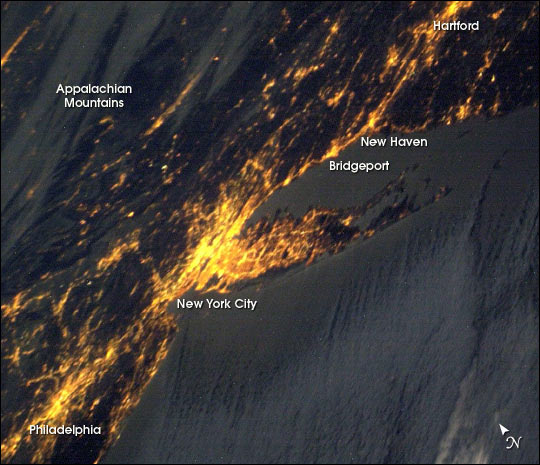 |
| Bright city lights along the coastline and interior delineate the eastern coast of the United States at night. Known as the "city that never sleeps," New York City with its population of more than 8 million residents (in 2000) is the largest and brightest metropolitan area along the coast. The metropolitan area straddles the Hudson River and spreads eastward over Long Island. Philadelphia is the second largest city in this image, situated south of New York (lower left in this scene). One of the most richly historic of U.S. cities, Philadelphia is where the Declaration of Independence was signed in 1776. The crew of the International Space Station took this image from a vantage point well to the northeast of the cities, with the camera pointed westward back towards New York City and the coast. The result is that the perspective is highly distorted but still recognizable. Low clouds have formed over the waters of the Atlantic and have settled into some of the valleys of the Appalachian Mountains to the northwest. |
| Images: | All Available Images Low-Resolution 63k |
|
| Mission: | ISS006 |
|
| Roll - Frame: | E - 18382 |
|
| Geographical Name: | USA-NEW YORK |
|
| Features: | NEW YORK CITY & EAST COAST LIGHTS, NIGHT |
|
| Center Lat x Lon: | 41.0N x 73W |
|
| Film Exposure: | N=Normal exposure, U=Under exposed, O=Over exposed, F=out of Focus |
|
| Percentage of Cloud Cover-CLDP: | 25 |
|
| Camera:: | N1 |
|
| Camera Tilt: | HO | LO=Low Oblique, HO=High Oblique, NV=Near Vertical |
| Camera Focal Length: | 58 |
|
| Nadir to Photo Center Direction: | W | The direction from the nadir to the center point, N=North, S=South, E=East, W=West |
| Stereo?: | Y=Yes there is an adjacent picture of the same area, N=No there isn't |
|
| Orbit Number: | 3763 |
|
| Date: | 20030118 | YYYYMMDD |
| Time: | 091723 | GMT HHMMSS |
| Nadir Lat: | 37.1N |
Latitude of suborbital point of spacecraft |
| Nadir Lon: | 60.6W |
Longitude of suborbital point of spacecraft |
| Sun Azimuth: | 99 | Clockwise angle in degrees from north to the sun measured at the nadir point |
| Space Craft Altitude: | 207 | nautical miles |
| Sun Elevation: | -23 | Angle in degrees between the horizon and the sun, measured at the nadir point |
| Land Views: | COAST, ISLAND |
|
| Water Views: | RIVER |
|
| Atmosphere Views: | |
|
| Man Made Views: | |
|
| City Views: | NEW YORK CITY, PHILADELPHIA |
|
Photo is not associated with any sequences | ||
| NASA Home Page |
JSC Home Page |
JSC Digital Image Collection |
Earth Science & Remote Sensing |
|
This service is provided by the International Space Station program and the JSC Earth Science & Remote Sensing Unit, ARES Division, Exploration Integration Science Directorate.

|