
Geographic Region: USA-TEXAS
Feature: DENVER CITY, WASSON OIL FIELD
|
Geographic Region: USA-TEXAS Feature: DENVER CITY, WASSON OIL FIELD |
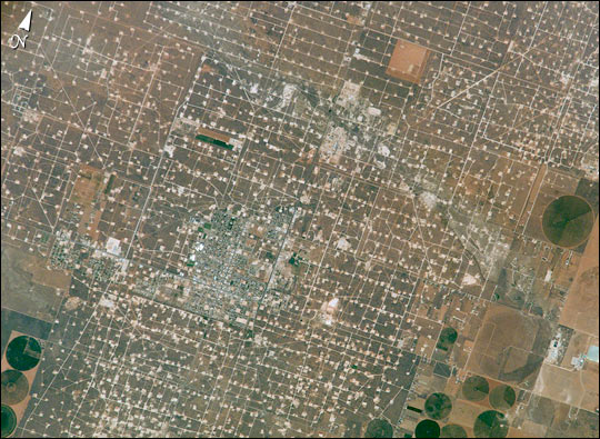 |
| Agriculture and the petroleum industry compete for land use near Denver City, Texas, southwest of Lubbock near the New Mexico border. The economy of this region is almost completely dependent on its underground resources of petroleum and water. Both resources result in distinctive land use patterns visible from space. Historically this area has produced vast quantities of oil and gas since development began in the 1930's. Note the fine, light-colored grid of roads and pipelines connecting well sites over this portion of the Wasson Oil Field, one of the state's most productive. Since the 1940s, agricultural land use has shifted from grazing to irrigated cultivation of cotton, sorghum, wheat, hay, and corn. The water supply is drawn from wells tapping the vast, but failing, Ogallala Aquifer. Note the large, circular center-pivot irrigation systems in the lower corners of the image. The largest is nearly a mile in diameter. |
| Images: | All Available Images Low-Resolution 81k |
|
| Mission: | ISS005 |
|
| Roll - Frame: | E - 9984 |
|
| Geographical Name: | USA-TEXAS |
|
| Features: | DENVER CITY, WASSON OIL FIELD |
|
| Center Lat x Lon: | 33.0N x 103W |
|
| Film Exposure: | N=Normal exposure, U=Under exposed, O=Over exposed, F=out of Focus |
|
| Percentage of Cloud Cover-CLDP: | 10 |
|
| Camera:: | E4 |
|
| Camera Tilt: | 18 | LO=Low Oblique, HO=High Oblique, NV=Near Vertical |
| Camera Focal Length: | 800 |
|
| Nadir to Photo Center Direction: | E | The direction from the nadir to the center point, N=North, S=South, E=East, W=West |
| Stereo?: | Y=Yes there is an adjacent picture of the same area, N=No there isn't |
|
| Orbit Number: | 1367 |
|
| Date: | 20020817 | YYYYMMDD |
| Time: | 181250 | GMT HHMMSS |
| Nadir Lat: | 33.3N |
Latitude of suborbital point of spacecraft |
| Nadir Lon: | 104.1W |
Longitude of suborbital point of spacecraft |
| Sun Azimuth: | 149 | Clockwise angle in degrees from north to the sun measured at the nadir point |
| Space Craft Altitude: | 212 | nautical miles |
| Sun Elevation: | 67 | Angle in degrees between the horizon and the sun, measured at the nadir point |
| Land Views: | |
|
| Water Views: | |
|
| Atmosphere Views: | |
|
| Man Made Views: | PIVOT IRRIGATION |
|
| City Views: | |
|
Photo is not associated with any sequences | ||
| NASA Home Page |
JSC Home Page |
JSC Digital Image Collection |
Earth Science & Remote Sensing |
|
This service is provided by the International Space Station program and the JSC Earth Science & Remote Sensing Unit, ARES Division, Exploration Integration Science Directorate.

|