
Geographic Region: USA-COLORADO
Feature: HAYMAN FIRE NEAR DENVER
|
Geographic Region: USA-COLORADO Feature: HAYMAN FIRE NEAR DENVER |
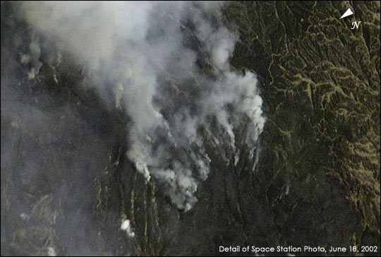 |
| Hayman Fire and Others Scorch Western U.S. This photograph taken by the new International Space Station crew on June 18, 2002, shows the eastern flank of the Hayman Fire burning in the foothills southwest of Denver. Astronauts use a variety of lenses and look angles as their orbits pass over wildfires to document the long-distance movements of smoke from the fires as well as details of the burning areas. In this detail view, you can see multiple smoke source points as the fire moves across the rough terrain. |
| Images: | All Available Images Low-Resolution 45k |
|
| Mission: | ISS005 |
|
| Roll - Frame: | E - 5416 |
|
| Geographical Name: | USA-COLORADO |
|
| Features: | HAYMAN FIRE NEAR DENVER |
|
| Center Lat x Lon: | 39.5N x 105W |
|
| Film Exposure: | N=Normal exposure, U=Under exposed, O=Over exposed, F=out of Focus |
|
| Percentage of Cloud Cover-CLDP: | 10 |
|
| Camera:: | E4 |
|
| Camera Tilt: | 40 | LO=Low Oblique, HO=High Oblique, NV=Near Vertical |
| Camera Focal Length: | 400 |
|
| Nadir to Photo Center Direction: | SE | The direction from the nadir to the center point, N=North, S=South, E=East, W=West |
| Stereo?: | Y=Yes there is an adjacent picture of the same area, N=No there isn't |
|
| Orbit Number: | 432 |
|
| Date: | 20020618 | YYYYMMDD |
| Time: | 191856 | GMT HHMMSS |
| Nadir Lat: | 42.1N |
Latitude of suborbital point of spacecraft |
| Nadir Lon: | 106.5W |
Longitude of suborbital point of spacecraft |
| Sun Azimuth: | 188 | Clockwise angle in degrees from north to the sun measured at the nadir point |
| Space Craft Altitude: | 212 | nautical miles |
| Sun Elevation: | 71 | Angle in degrees between the horizon and the sun, measured at the nadir point |
| Land Views: | |
|
| Water Views: | |
|
| Atmosphere Views: | SMOKE |
|
| Man Made Views: | |
|
| City Views: | |
|
Photo is not associated with any sequences | ||
| NASA Home Page |
JSC Home Page |
JSC Digital Image Collection |
Earth Science & Remote Sensing |
|
This service is provided by the International Space Station program and the JSC Earth Science & Remote Sensing Unit, ARES Division, Exploration Integration Science Directorate.

|