
Geographic Region: USA-FLORIDA
Feature: KEY WEST
|
Geographic Region: USA-FLORIDA Feature: KEY WEST |
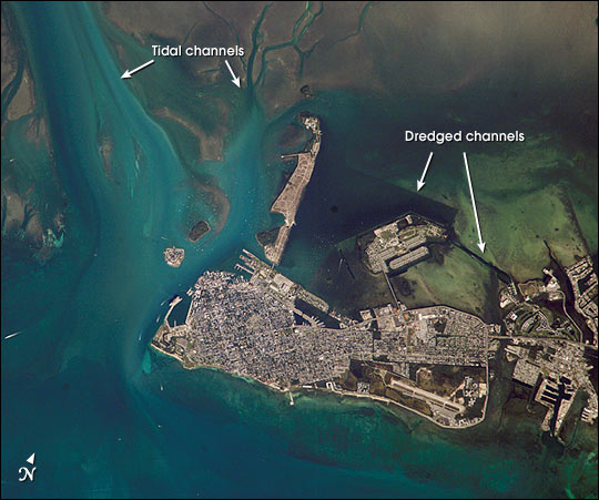 |
| Turquoise blue waters, coral reefs and sandy beaches were apparently on the minds of International Space Station astronauts last week. As they passed over the Florida Keys, they acquired a sequence of images from Key West eastward along the outer keys. The detail of the images showcases the clarity of the Caribbean waters, and allows for mapping of both land use and shallow marine features. This image of Key West shows the intensive built-up area of the town, the offshore sand flats and grassbeds surrounding Key West, the patterns of natural tidal channels and artificially dredged channels that allow boat access to the local marinas. |
| Images: | All Available Images Low-Resolution 59k |
|
| Mission: | ISS005 |
|
| Roll - Frame: | E - 18039 |
|
| Geographical Name: | USA-FLORIDA |
|
| Features: | KEY WEST |
|
| Center Lat x Lon: | 24.5N x 82W |
|
| Film Exposure: | N=Normal exposure, U=Under exposed, O=Over exposed, F=out of Focus |
|
| Percentage of Cloud Cover-CLDP: | 10 |
|
| Camera:: | E4 |
|
| Camera Tilt: | 5 | LO=Low Oblique, HO=High Oblique, NV=Near Vertical |
| Camera Focal Length: | 800 |
|
| Nadir to Photo Center Direction: | S | The direction from the nadir to the center point, N=North, S=South, E=East, W=West |
| Stereo?: | Y=Yes there is an adjacent picture of the same area, N=No there isn't |
|
| Orbit Number: | 2394 |
|
| Date: | 20021022 | YYYYMMDD |
| Time: | 134232 | GMT HHMMSS |
| Nadir Lat: | 24.8N |
Latitude of suborbital point of spacecraft |
| Nadir Lon: | 81.9W |
Longitude of suborbital point of spacecraft |
| Sun Azimuth: | 119 | Clockwise angle in degrees from north to the sun measured at the nadir point |
| Space Craft Altitude: | 207 | nautical miles |
| Sun Elevation: | 28 | Angle in degrees between the horizon and the sun, measured at the nadir point |
| Land Views: | |
|
| Water Views: | |
|
| Atmosphere Views: | |
|
| Man Made Views: | |
|
| City Views: | KEY WEST |
|
Photo is not associated with any sequences | ||
| NASA Home Page |
JSC Home Page |
JSC Digital Image Collection |
Earth Science & Remote Sensing |
|
This service is provided by the International Space Station program and the JSC Earth Science & Remote Sensing Unit, ARES Division, Exploration Integration Science Directorate.

|