
Geographic Region: CUBA
Feature: LA HAVANA
|
Geographic Region: CUBA Feature: LA HAVANA |
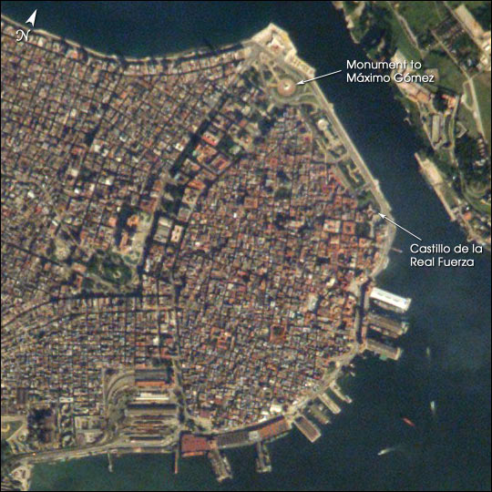 |
| The red tile roofs and historic buildings of Cuba's Old Havana appear distinctly in this high-resolution photograph taken by astronauts on board the International Space Station. Founded by the Spanish in 1519, the old city was strongly fortified against attacks by pirates. Some of these fortifications, such as the Castillo de la Real Fuerza, are readily distinguishable at the 6-m/pixel resolution of the photograph, which is displayed here in actual pixels. The complete image includes most of the rest of modern Havana as well. |
| Images: | All Available Images Low-Resolution 91k |
|
| Mission: | ISS005 |
|
| Roll - Frame: | E - 18035 |
|
| Geographical Name: | CUBA |
|
| Features: | LA HAVANA |
|
| Center Lat x Lon: | 23.0N x 82.5W |
|
| Film Exposure: | N=Normal exposure, U=Under exposed, O=Over exposed, F=out of Focus |
|
| Percentage of Cloud Cover-CLDP: | 10 |
|
| Camera:: | E4 |
|
| Camera Tilt: | 15 | LO=Low Oblique, HO=High Oblique, NV=Near Vertical |
| Camera Focal Length: | 800 |
|
| Nadir to Photo Center Direction: | E | The direction from the nadir to the center point, N=North, S=South, E=East, W=West |
| Stereo?: | Y=Yes there is an adjacent picture of the same area, N=No there isn't |
|
| Orbit Number: | 2394 |
|
| Date: | 20021022 | YYYYMMDD |
| Time: | 134157 | GMT HHMMSS |
| Nadir Lat: | 23.1N |
Latitude of suborbital point of spacecraft |
| Nadir Lon: | 83.4W |
Longitude of suborbital point of spacecraft |
| Sun Azimuth: | 117 | Clockwise angle in degrees from north to the sun measured at the nadir point |
| Space Craft Altitude: | 208 | nautical miles |
| Sun Elevation: | 27 | Angle in degrees between the horizon and the sun, measured at the nadir point |
| Land Views: | |
|
| Water Views: | |
|
| Atmosphere Views: | |
|
| Man Made Views: | |
|
| City Views: | HAVANA |
|
Photo is not associated with any sequences | ||
| NASA Home Page |
JSC Home Page |
JSC Digital Image Collection |
Earth Science & Remote Sensing |
|
This service is provided by the International Space Station program and the JSC Earth Science & Remote Sensing Unit, ARES Division, Exploration Integration Science Directorate.

|