Geographic Region: EASTER ISLAND
Feature: EASTER ISLAND
|
Geographic Region: EASTER ISLAND Feature: EASTER ISLAND |
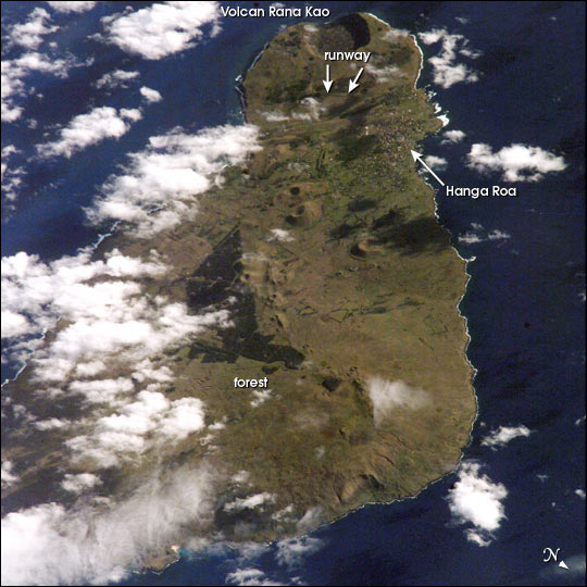 |
| On September 25, 2002, astronauts aboard the International Space Station viewed Easter Island, one of the most remote locations on Earth. Easter Island is more than 2000 miles from the closest populations on Tahiti and Chile--even more remote than astronauts orbiting at 210 n.mi. above the Earth. The island is less than 15 miles long and, until now, has been a photographic challenge for astronauts on space missions. Although not visible here, Easter Island is perhaps most famous for the giant stone monoliths, known as Moai, that have been placed along the coastline. Archaeologists believe the island was discovered and colonized by Polynesians at about 400 AD. Subsequently, a unique culture developed. The human population grew to levels that could not be sustained by the island. A civil war resulted, and the island's deforestation and ecosystem collapse was nearly complete. Today, a new forest (primarily eucalyptus) has been established in the center of the island (dark green). The geography of the island is dominated by volcanic landforms, including the large crater Rana Kao at the southwest end of the island and a line of cinder cones that stretch north from the central mountain. A final feature (difficult to see) is the very long runway (Chile's longest) near Rana Kao. The airport serves as an emergency landing site for the Space Shuttle. |
| Images: | All Available Images Low-Resolution 70k |
|
| Mission: | ISS005 |
|
| Roll - Frame: | E - 15458 |
|
| Geographical Name: | EASTER ISLAND |
|
| Features: | EASTER ISLAND |
|
| Center Lat x Lon: | 27S x 109.5W |
|
| Film Exposure: | N=Normal exposure, U=Under exposed, O=Over exposed, F=out of Focus |
|
| Percentage of Cloud Cover-CLDP: | 25 |
|
| Camera:: | E4 |
|
| Camera Tilt: | 47 | LO=Low Oblique, HO=High Oblique, NV=Near Vertical |
| Camera Focal Length: | 800 |
|
| Nadir to Photo Center Direction: | S | The direction from the nadir to the center point, N=North, S=South, E=East, W=West |
| Stereo?: | Y=Yes there is an adjacent picture of the same area, N=No there isn't |
|
| Orbit Number: | 1978 |
|
| Date: | 20020925 | YYYYMMDD |
| Time: | 232107 | GMT HHMMSS |
| Nadir Lat: | 23.6S |
Latitude of suborbital point of spacecraft |
| Nadir Lon: | 108W |
Longitude of suborbital point of spacecraft |
| Sun Azimuth: | 280 | Clockwise angle in degrees from north to the sun measured at the nadir point |
| Space Craft Altitude: | 205 | nautical miles |
| Sun Elevation: | 24 | Angle in degrees between the horizon and the sun, measured at the nadir point |
| Land Views: | CRATER, FOREST, ISLAND, MOUNTAIN |
|
| Water Views: | |
|
| Atmosphere Views: | |
|
| Man Made Views: | AIRPORT, DEFORESTATION |
|
| City Views: | |
|
Photo is not associated with any sequences | ||
| NASA Home Page |
JSC Home Page |
JSC Digital Image Collection |
Earth Science & Remote Sensing |
|
This service is provided by the International Space Station program and the JSC Earth Science & Remote Sensing Unit, ARES Division, Exploration Integration Science Directorate.

|