
Geographic Region: CHILE
Feature: CAMANA, EL CONDO, AGR.
|
Geographic Region: CHILE Feature: CAMANA, EL CONDO, AGR. |
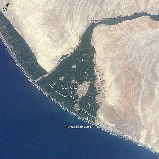 |
| A tsunami washed over the low-lying coastal resort region near Camana, southern Peru, following a strong earthquake on June 23, 2001. The earthquake was one of the most powerful of the last 35 years and had a magnitude of 8.4. After the initial quake, coastal residents witnessed a sudden drawdown of the ocean and knew a tsunami was imminent. They had less than 20 minutes to reach higher ground before the tsunami hit. Waves as high as 8 m came in four destructive surges reaching as far as 1.2 km inland. The dashed line marks the approximate area of tsunami inundation. Thousands of buildings were destroyed, and the combined earthquake and tsunami killed as many as 139 people. This image (ISS004-E-6128)was taken by astronauts onboard the International Space Station on 10 January 2002. It shows some of the reasons that the Camana area was so vulnerable to tsunami damage. The area has a 1 km band of coastal plain that is less than 5 m in elevation. Much of the plain can be seen by the bright green fields of irrigated agriculture that contrast with the light-colored desert high ground. Many of the tsunami-related deaths were workers in the onion fields in the coastal plain that were unwilling to leave their jobs before the end of the shift. A number of lives were spared because the tsunami occurred during the resort off-season, during the daylight when people could see the ocean drawdown, and during one of the lowest tides of the year. |
| Images: | All Available Images Low-Resolution 72k |
|
| Mission: | ISS004 |
|
| Roll - Frame: | E - 6128 |
|
| Geographical Name: | CHILE |
|
| Features: | CAMANA, EL CONDO, AGR. |
|
| Center Lat x Lon: | 16.5S x 72.5W |
|
| Film Exposure: | N=Normal exposure, U=Under exposed, O=Over exposed, F=out of Focus |
|
| Percentage of Cloud Cover-CLDP: | 10 |
|
| Camera:: | E4 |
|
| Camera Tilt: | 14 | LO=Low Oblique, HO=High Oblique, NV=Near Vertical |
| Camera Focal Length: | 400 |
|
| Nadir to Photo Center Direction: | E | The direction from the nadir to the center point, N=North, S=South, E=East, W=West |
| Stereo?: | Y=Yes there is an adjacent picture of the same area, N=No there isn't |
|
| Orbit Number: | 1950 |
|
| Date: | 20020110 | YYYYMMDD |
| Time: | 184227 | GMT HHMMSS |
| Nadir Lat: | 16.4S |
Latitude of suborbital point of spacecraft |
| Nadir Lon: | 73.4W |
Longitude of suborbital point of spacecraft |
| Sun Azimuth: | 253 | Clockwise angle in degrees from north to the sun measured at the nadir point |
| Space Craft Altitude: | 216 | nautical miles |
| Sun Elevation: | 65 | Angle in degrees between the horizon and the sun, measured at the nadir point |
| Land Views: | DESERT, PLAIN |
|
| Water Views: | OCEAN |
|
| Atmosphere Views: | |
|
| Man Made Views: | AGRICULTURE |
|
| City Views: | |
|
Photo is not associated with any sequences | ||
| NASA Home Page |
JSC Home Page |
JSC Digital Image Collection |
Earth Science & Remote Sensing |
|
This service is provided by the International Space Station program and the JSC Earth Science & Remote Sensing Unit, ARES Division, Exploration Integration Science Directorate.

|