
Geographic Region: BELIZE
Feature: SMOKE PLUMES, COAST, REEFS
|
Geographic Region: BELIZE Feature: SMOKE PLUMES, COAST, REEFS |
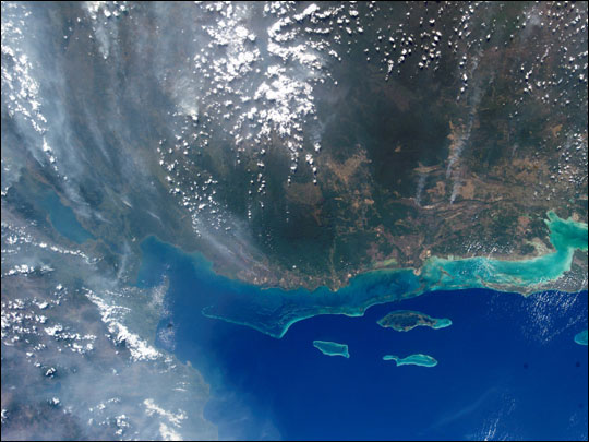 |
| Fires in Central America The bright blue water of the Gulf of Honduras contrasts sharply with the smokey pall over Guatemala and Belize in this photograph taken from the International Space Station. Fires in the Yucatan Penninsula and northern Central America began burning in early April, and intensified by the end of the month. |
| Images: | All Available Images Low-Resolution 60k |
|
| Mission: | ISS004 |
|
| Roll - Frame: | E - 11078 |
|
| Geographical Name: | BELIZE |
|
| Features: | SMOKE PLUMES, COAST, REEFS |
|
| Center Lat x Lon: | 17.5N x 88.5W |
|
| Film Exposure: | N=Normal exposure, U=Under exposed, O=Over exposed, F=out of Focus |
|
| Percentage of Cloud Cover-CLDP: | 25 |
|
| Camera:: | E4 |
|
| Camera Tilt: | 33 | LO=Low Oblique, HO=High Oblique, NV=Near Vertical |
| Camera Focal Length: | 25 |
|
| Nadir to Photo Center Direction: | E | The direction from the nadir to the center point, N=North, S=South, E=East, W=West |
| Stereo?: | Y=Yes there is an adjacent picture of the same area, N=No there isn't |
|
| Orbit Number: | 3684 |
|
| Date: | 20020501 | YYYYMMDD |
| Time: | 212648 | GMT HHMMSS |
| Nadir Lat: | 18.2N |
Latitude of suborbital point of spacecraft |
| Nadir Lon: | 90.7W |
Longitude of suborbital point of spacecraft |
| Sun Azimuth: | 275 | Clockwise angle in degrees from north to the sun measured at the nadir point |
| Space Craft Altitude: | 213 | nautical miles |
| Sun Elevation: | 40 | Angle in degrees between the horizon and the sun, measured at the nadir point |
| Land Views: | |
|
| Water Views: | GULF, REEF |
|
| Atmosphere Views: | |
|
| Man Made Views: | |
|
| City Views: | BELIZE |
|
Photo is not associated with any sequences | ||
| NASA Home Page |
JSC Home Page |
JSC Digital Image Collection |
Earth Science & Remote Sensing |
|
This service is provided by the International Space Station program and the JSC Earth Science & Remote Sensing Unit, ARES Division, Exploration Integration Science Directorate.

|