
Geographic Region: FRANCE
Feature: PARIS, SEINE RIVER
|
Geographic Region: FRANCE Feature: PARIS, SEINE RIVER |
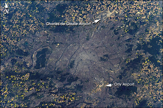 |
| The colors of the agricultural fields surrounding Paris are striking in the springtime, even when viewed from a 400 km orbital altitude. Astronauts on board the International Space Station photographed Paris using a digital camera and downlinked the image to the ground. |
| Images: | All Available Images Low-Resolution 95k |
|
| Mission: | ISS004 |
|
| Roll - Frame: | E - 10414 |
|
| Geographical Name: | FRANCE |
|
| Features: | PARIS, SEINE RIVER |
|
| Center Lat x Lon: | 49.0N x 2.5E |
|
| Film Exposure: | N=Normal exposure, U=Under exposed, O=Over exposed, F=out of Focus |
|
| Percentage of Cloud Cover-CLDP: | 10 |
|
| Camera:: | E4 |
|
| Camera Tilt: | 48 | LO=Low Oblique, HO=High Oblique, NV=Near Vertical |
| Camera Focal Length: | 185 |
|
| Nadir to Photo Center Direction: | E | The direction from the nadir to the center point, N=North, S=South, E=East, W=West |
| Stereo?: | Y=Yes there is an adjacent picture of the same area, N=No there isn't |
|
| Orbit Number: | 3571 |
|
| Date: | 20020424 | YYYYMMDD |
| Time: | 151837 | GMT HHMMSS |
| Nadir Lat: | 48.0N |
Latitude of suborbital point of spacecraft |
| Nadir Lon: | 1.2W |
Longitude of suborbital point of spacecraft |
| Sun Azimuth: | 246 | Clockwise angle in degrees from north to the sun measured at the nadir point |
| Space Craft Altitude: | 210 | nautical miles |
| Sun Elevation: | 37 | Angle in degrees between the horizon and the sun, measured at the nadir point |
| Land Views: | |
|
| Water Views: | RIVER |
|
| Atmosphere Views: | |
|
| Man Made Views: | AIRPORT |
|
| City Views: | PARIS |
|
Photo is not associated with any sequences | ||
| NASA Home Page |
JSC Home Page |
JSC Digital Image Collection |
Earth Science & Remote Sensing |
|
This service is provided by the International Space Station program and the JSC Earth Science & Remote Sensing Unit, ARES Division, Exploration Integration Science Directorate.

|