 Photo #: ISS003-E-6430 Date: Oct. 2001
Geographic Region: ASTRONOMICAL OBJECTS
Feature: MOON
|
Photo #: ISS003-E-6430 Date: Oct. 2001 Geographic Region: ASTRONOMICAL OBJECTS Feature: MOON |
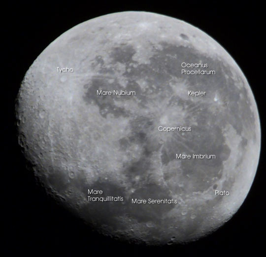 |
| Inspired by the nearly-full moon, space station astronauts used an 800 mm lens to study the craters and mare. This view, taken October 5, 2001, is centered on Crater Copernicus, surrounded by the Mare Serenitatis and Mare Tranquillitatis (Sea of Serenity and Sea of Tranquility), Mare Imbrium (Sea of Rains), Oceanus Procellarum (Ocean of Storms) and Mare Nubium (Sea of Clouds). The bright crater and ejecta trails of Tycho dominate this near-side view. For scale, the crater of Tycho is 85 km in diameter. |
| Images: | All Available Images Low-Resolution 32k |
|
| Mission: | ISS003 |
|
| Roll - Frame: | E - 6430 |
|
| Geographical Name: | ASTRONOMICAL OBJECTS |
|
| Features: | MOON |
|
| Center Lat x Lon: | N x E |
|
| Film Exposure: | N=Normal exposure, U=Under exposed, O=Over exposed, F=out of Focus |
|
| Percentage of Cloud Cover-CLDP: | 0 |
|
| Camera:: | E2 |
|
| Camera Tilt: | LO=Low Oblique, HO=High Oblique, NV=Near Vertical |
|
| Camera Focal Length: | 800 |
|
| Nadir to Photo Center Direction: | The direction from the nadir to the center point, N=North, S=South, E=East, W=West |
|
| Stereo?: | Y=Yes there is an adjacent picture of the same area, N=No there isn't |
|
| Orbit Number: | 438 |
|
| Date: | 20011005 | YYYYMMDD |
| Time: | 230311 | GMT HHMMSS |
| Nadir Lat: | 30.9S |
Latitude of suborbital point of spacecraft |
| Nadir Lon: | 99.0E |
Longitude of suborbital point of spacecraft |
| Sun Azimuth: | 95 | Clockwise angle in degrees from north to the sun measured at the nadir point |
| Space Craft Altitude: | 208 | nautical miles |
| Sun Elevation: | 1 | Angle in degrees between the horizon and the sun, measured at the nadir point |
| Land Views: | CRATERS, MOON |
|
| Water Views: | |
|
| Atmosphere Views: | |
|
| Man Made Views: | |
|
| City Views: | |
|
Photo is not associated with any sequences | ||
| NASA Home Page |
JSC Home Page |
JSC Digital Image Collection |
Earth Science & Remote Sensing |
|
This service is provided by the International Space Station program and the JSC Earth Science & Remote Sensing Unit, ARES Division, Exploration Integration Science Directorate.

|