 Photo #: ISS003-E-6152 Date: Oct. 2001
Geographic Region: AURORA
Feature: AURORA BOREALIS
|
Photo #: ISS003-E-6152 Date: Oct. 2001 Geographic Region: AURORA Feature: AURORA BOREALIS |
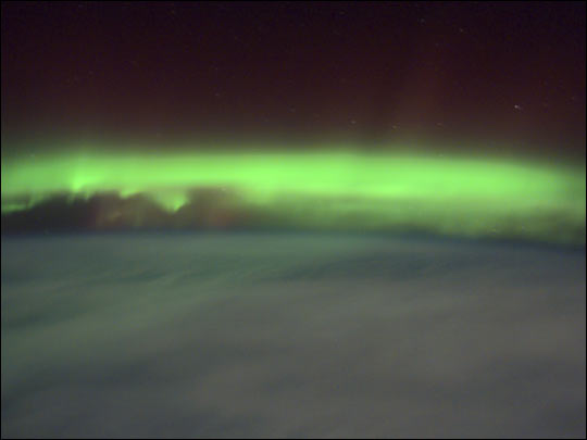 |
| As geomagnetic storms cause beautiful displays of aurora across the United States, astronauts onboard the International Space Station also have the opportunity to take a look. Green colors of the aurora are dominant in this image captured by a digital still camera on October 4, 2001. Auroras are caused when high-energy electrons pour down from the Earth's magnetosphere and collide with atoms. Green aurora occurs from about 100 km to 250 km altitude and is caused by the emission of 5577 Angstrom wavelength light from oxygen atoms. The light is emitted when the atoms return to their original unexcited state. At times of peaks in solar activity, there are more geomagnetic storms and this increases the auroral activity viewed on Earth and by astronauts from orbit. By using a digital camera with a long exposure time, astronauts can capture a part of the light from the multicolored displays they observe, and downlink those images to Earth. |
| Images: | All Available Images Low-Resolution 14k |
|
| Mission: | ISS003 |
|
| Roll - Frame: | E - 6152 |
|
| Geographical Name: | AURORA |
|
| Features: | AURORA BOREALIS |
|
| Center Lat x Lon: | N x E |
|
| Film Exposure: | N=Normal exposure, U=Under exposed, O=Over exposed, F=out of Focus |
|
| Percentage of Cloud Cover-CLDP: | ||
| Camera:: | E2 |
|
| Camera Tilt: | LO=Low Oblique, HO=High Oblique, NV=Near Vertical |
|
| Camera Focal Length: | 50 |
|
| Nadir to Photo Center Direction: | The direction from the nadir to the center point, N=North, S=South, E=East, W=West |
|
| Stereo?: | Y=Yes there is an adjacent picture of the same area, N=No there isn't |
|
| Orbit Number: | 408 |
|
| Date: | 20011004 | YYYYMMDD |
| Time: | 002132 | GMT HHMMSS |
| Nadir Lat: | 50.6N |
Latitude of suborbital point of spacecraft |
| Nadir Lon: | 43.7W |
Longitude of suborbital point of spacecraft |
| Sun Azimuth: | 315 | Clockwise angle in degrees from north to the sun measured at the nadir point |
| Space Craft Altitude: | 203 | nautical miles |
| Sun Elevation: | -35 | Angle in degrees between the horizon and the sun, measured at the nadir point |
| Land Views: | |
|
| Water Views: | |
|
| Atmosphere Views: | AURORA |
|
| Man Made Views: | |
|
| City Views: | |
|
Photo is not associated with any sequences | ||
| NASA Home Page |
JSC Home Page |
JSC Digital Image Collection |
Earth Science & Remote Sensing |
|
This service is provided by the International Space Station program and the JSC Earth Science & Remote Sensing Unit, ARES Division, Exploration Integration Science Directorate.

|