Geographic Region: CHILE
Feature: BRUGGEN GLACIER, EYRE FJORD
|
Geographic Region: CHILE Feature: BRUGGEN GLACIER, EYRE FJORD |
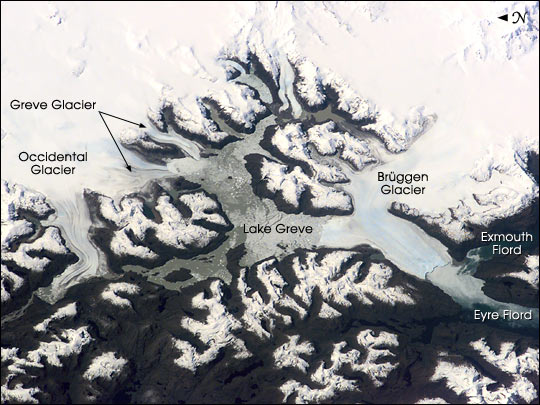 |
| The Expedition 3 crew of the International Space Station caught a rare glimpse of the massive ice fields and glaciers of Patagonia early in the afternoon on September 25, 2001. This part of the South American coast sees frequent storms and is often obscured from view by cloud cover. Bruggen Glacier in southern Chile is the largest western outflow from the Southern Patagonian Ice Field and, unlike most glaciers worldwide, advanced significantly since 1945. From 1945 to 1976, Bruggen surged 5 km across the Eyre Fjord, reaching the western shore by 1962 and cutting off Lake Greve from the sea. The glacier continued advancing both northward and southward in the fjord to near its present position before stabilizing. The growth covers a distance of more than 10 km north to south, adding nearly 60 square km of ice. |
| Images: | All Available Images Low-Resolution 66k |
|
| Mission: | ISS003 |
|
| Roll - Frame: | E - 6061 |
|
| Geographical Name: | CHILE |
|
| Features: | BRUGGEN GLACIER, EYRE FJORD |
|
| Center Lat x Lon: | 49S x 74W |
|
| Film Exposure: | N=Normal exposure, U=Under exposed, O=Over exposed, F=out of Focus |
|
| Percentage of Cloud Cover-CLDP: | 10 |
|
| Camera:: | E2 |
|
| Camera Tilt: | HO | LO=Low Oblique, HO=High Oblique, NV=Near Vertical |
| Camera Focal Length: | 180 |
|
| Nadir to Photo Center Direction: | W | The direction from the nadir to the center point, N=North, S=South, E=East, W=West |
| Stereo?: | Y=Yes there is an adjacent picture of the same area, N=No there isn't |
|
| Orbit Number: | 278 |
|
| Date: | 20010925 | YYYYMMDD |
| Time: | 171931 | GMT HHMMSS |
| Nadir Lat: | 50.5S |
Latitude of suborbital point of spacecraft |
| Nadir Lon: | 69.1W |
Longitude of suborbital point of spacecraft |
| Sun Azimuth: | 343 | Clockwise angle in degrees from north to the sun measured at the nadir point |
| Space Craft Altitude: | 214 | nautical miles |
| Sun Elevation: | 40 | Angle in degrees between the horizon and the sun, measured at the nadir point |
| Land Views: | COAST, GLACIER |
|
| Water Views: | ICE, LAKE |
|
| Atmosphere Views: | |
|
| Man Made Views: | |
|
| City Views: | |
|
Photo is not associated with any sequences | ||
| NASA Home Page |
JSC Home Page |
JSC Digital Image Collection |
Earth Science & Remote Sensing |
|
This service is provided by the International Space Station program and the JSC Earth Science & Remote Sensing Unit, ARES Division, Exploration Integration Science Directorate.

|