Geographic Region: UK-ENGLAND
Feature: GREENWICH, THAMES RIVER
|
Geographic Region: UK-ENGLAND Feature: GREENWICH, THAMES RIVER |
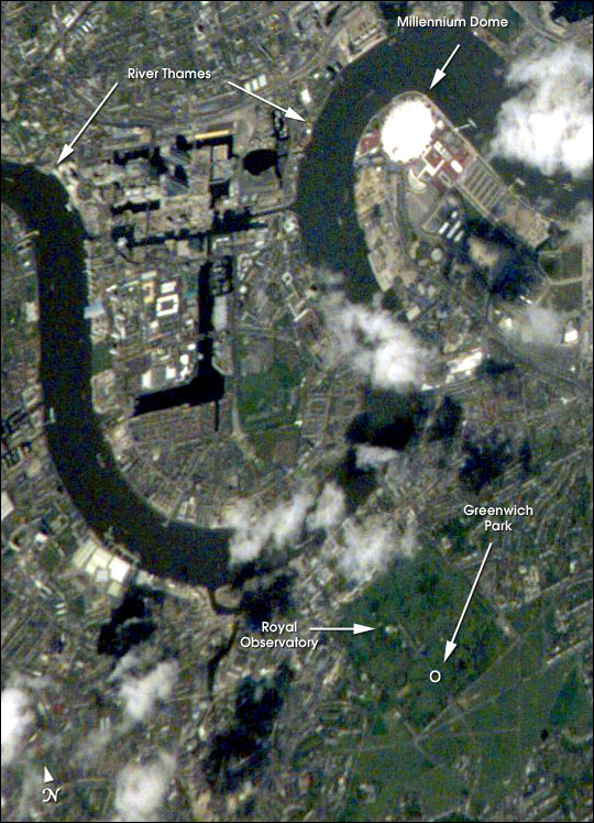 |
| Greenwich is situated on the south shore of a sharp bend in the River Thames, just southeast of the City of London and is part of Greater London. Here is located the world famous Royal Observatory where the Prime Meridian, dividing East and West Longitude, was defined by international agreement in 1884. In this detailed portion of a larger area photographed by the crew of the International Space Station on May 8, 2000, the location of the Observatory itself is roughly the small, light area in the northern, wooded part of Greenwich Park. The River Thames with its port facilities and industrial sites winds its way, left to right, across the scene. The large, white, circular structure is the Millennium Dome. Over 1 km in diameter and 50 m high, it was built as an exhibition center to commemorate the new millennium, which chronologically began at the Prime Meridian. |
| Images: | All Available Images Low-Resolution 125k |
|
| Mission: | ISS002 |
|
| Roll - Frame: | E - 6638 |
|
| Geographical Name: | UK-ENGLAND |
|
| Features: | GREENWICH, THAMES RIVER |
|
| Center Lat x Lon: | 51.5N x .0E |
|
| Film Exposure: | N=Normal exposure, U=Under exposed, O=Over exposed, F=out of Focus |
|
| Percentage of Cloud Cover-CLDP: | 10 |
|
| Camera:: | E2 |
|
| Camera Tilt: | 20 | LO=Low Oblique, HO=High Oblique, NV=Near Vertical |
| Camera Focal Length: | 800 |
|
| Nadir to Photo Center Direction: | NE | The direction from the nadir to the center point, N=North, S=South, E=East, W=West |
| Stereo?: | Y=Yes there is an adjacent picture of the same area, N=No there isn't |
|
| Orbit Number: | 2089 |
|
| Date: | 20010508 | YYYYMMDD |
| Time: | 112044 | GMT HHMMSS |
| Nadir Lat: | 50.5N |
Latitude of suborbital point of spacecraft |
| Nadir Lon: | 0.7W |
Longitude of suborbital point of spacecraft |
| Sun Azimuth: | 163 | Clockwise angle in degrees from north to the sun measured at the nadir point |
| Space Craft Altitude: | 205 | nautical miles |
| Sun Elevation: | 56 | Angle in degrees between the horizon and the sun, measured at the nadir point |
| Land Views: | |
|
| Water Views: | RIVER |
|
| Atmosphere Views: | |
|
| Man Made Views: | PORT |
|
| City Views: | LONDON |
|
Photo is not associated with any sequences | ||
| NASA Home Page |
JSC Home Page |
JSC Digital Image Collection |
Earth Science & Remote Sensing |
|
This service is provided by the International Space Station program and the JSC Earth Science & Remote Sensing Unit, ARES Division, Exploration Integration Science Directorate.

|