
Geographic Region: USA-NEW YORK
Feature: MANHATTEN ISLAND
|
Geographic Region: USA-NEW YORK Feature: MANHATTEN ISLAND |
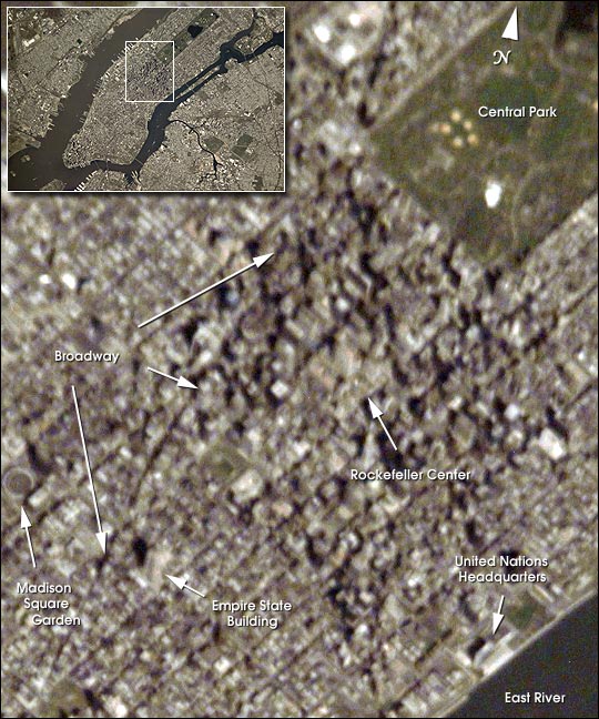 |
| It was a fine spring day on April 28, 2001, in New York City when the Expedition 2 crew of Space Station Alpha acquired this digital photograph. This ESC image was taken of Manhattan using an 800 mm lens (see inset) from an orbit altitude of 383 km. This particular lens can achieve spatial resolutions less than 6 meters. A detailed slice of the full image permits identification of a number of well-known landmarks of the Big Apple. It is late morning and the view is slightly oblique so that both the sunlit sides and shadows of taller buildings give perspective and depth to the scene. The lower end of a greening Central Park is to the upper right. Broadway angles across the center, breaking with the grid of city blocks. Madison Square Gardens is the circular feature at the left edge of the image. The Empire State Building casts its profile shadow northwestward towards Broadway. The Rockefeller Center complex is near the middle of this slice, and the United Nations Headquarters is located on the East River to the lower right. |
| Images: | All Available Images Low-Resolution 96k |
|
| Mission: | ISS002 |
|
| Roll - Frame: | E - 6333 |
|
| Geographical Name: | USA-NEW YORK |
|
| Features: | MANHATTEN ISLAND |
|
| Center Lat x Lon: | 40.5N x 74W |
|
| Film Exposure: | N=Normal exposure, U=Under exposed, O=Over exposed, F=out of Focus |
|
| Percentage of Cloud Cover-CLDP: | 0 |
|
| Camera:: | E2 |
|
| Camera Tilt: | 23 | LO=Low Oblique, HO=High Oblique, NV=Near Vertical |
| Camera Focal Length: | 800 |
|
| Nadir to Photo Center Direction: | NW | The direction from the nadir to the center point, N=North, S=South, E=East, W=West |
| Stereo?: | Y=Yes there is an adjacent picture of the same area, N=No there isn't |
|
| Orbit Number: | 1935 |
|
| Date: | 20010428 | YYYYMMDD |
| Time: | 154045 | GMT HHMMSS |
| Nadir Lat: | 39.4N |
Latitude of suborbital point of spacecraft |
| Nadir Lon: | 73.1W |
Longitude of suborbital point of spacecraft |
| Sun Azimuth: | 144 | Clockwise angle in degrees from north to the sun measured at the nadir point |
| Space Craft Altitude: | 204 | nautical miles |
| Sun Elevation: | 61 | Angle in degrees between the horizon and the sun, measured at the nadir point |
| Land Views: | |
|
| Water Views: | RIVER |
|
| Atmosphere Views: | |
|
| Man Made Views: | |
|
| City Views: | NEW YORK CITY |
|
Photo is not associated with any sequences | ||
| NASA Home Page |
JSC Home Page |
JSC Digital Image Collection |
Earth Science & Remote Sensing |
|
This service is provided by the International Space Station program and the JSC Earth Science & Remote Sensing Unit, ARES Division, Exploration Integration Science Directorate.

|