
Geographic Region: BOLIVIA
Feature: TIERRAS BAJAS DEFORESTATION
|
Geographic Region: BOLIVIA Feature: TIERRAS BAJAS DEFORESTATION |
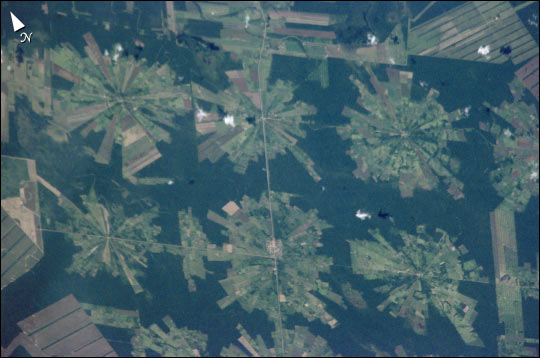 |
| Tierras Bajas Deforestation, Bolivia This digital photograph of deforestation associated with the Tierras Bajas project in eastern Bolivia was taken by astronauts from the International Space Station on April 16, 2001. The spatial resolution of the original digital photograph is about 6 meters per pixel. The area east of Santa Cruz was originally dry tropical forest. As part of the Tierras Bajas project, people have been resettled from the Altiplano to cultivate soybeans. Each agricultural "pin wheel" pattern is centered on a small community. The communities are then spaced evenly across the landscape at 5-km intervals. Roadways can be seen connecting each town center. |
| Images: | All Available Images Low-Resolution 44k |
|
| Mission: | ISS002 |
|
| Roll - Frame: | E - 5654 |
|
| Geographical Name: | BOLIVIA |
|
| Features: | TIERRAS BAJAS DEFORESTATION |
|
| Center Lat x Lon: | 17.5S x 60.5W |
|
| Film Exposure: | N=Normal exposure, U=Under exposed, O=Over exposed, F=out of Focus |
|
| Percentage of Cloud Cover-CLDP: | 10 |
|
| Camera:: | E2 |
|
| Camera Tilt: | 16 | LO=Low Oblique, HO=High Oblique, NV=Near Vertical |
| Camera Focal Length: | 800 |
|
| Nadir to Photo Center Direction: | E | The direction from the nadir to the center point, N=North, S=South, E=East, W=West |
| Stereo?: | Y=Yes there is an adjacent picture of the same area, N=No there isn't |
|
| Orbit Number: | 1748 |
|
| Date: | 20010416 | YYYYMMDD |
| Time: | 160430 | GMT HHMMSS |
| Nadir Lat: | 17.4S |
Latitude of suborbital point of spacecraft |
| Nadir Lon: | 61.5W |
Longitude of suborbital point of spacecraft |
| Sun Azimuth: | 1 | Clockwise angle in degrees from north to the sun measured at the nadir point |
| Space Craft Altitude: | 206 | nautical miles |
| Sun Elevation: | 62 | Angle in degrees between the horizon and the sun, measured at the nadir point |
| Land Views: | |
|
| Water Views: | |
|
| Atmosphere Views: | |
|
| Man Made Views: | DEFORESTATION |
|
| City Views: | |
|
Photo is not associated with any sequences | ||
| NASA Home Page |
JSC Home Page |
JSC Digital Image Collection |
Earth Science & Remote Sensing |
|
This service is provided by the International Space Station program and the JSC Earth Science & Remote Sensing Unit, ARES Division, Exploration Integration Science Directorate.

|