
Geographic Region: USA-NEW YORK
Feature: NIAGARA FALLS
|
Geographic Region: USA-NEW YORK Feature: NIAGARA FALLS |
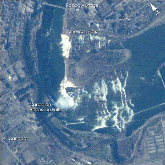 |
| Mark Twain once said of Niagara Falls: "Although it was wonderful to see all that water tumbling down, it would be even more wonderful to see all that water tumbling up." Viewing the tumbling waters of the Niagara River from the microgravity environment of the International Space Station, astronauts recently acquired this image. They were at an orbit of 207 nautical miles (383 km) above the Falls, and used a digital camera with an 800 mm lens. In taking these kinds of detailed images, Space Station crewmembers have compensated for the relative motion of the Earth, thus achieving spatial resolutions of less than 6 m and surpassing the previous records for spatial resolution from human spaceflight. Details of the city of Niagara Falls are easy to see; for spatial reference, the American falls is 328 m wide (1075 ft), and the Horseshoe Falls is 675 m wide (2200 ft). The Niagara River forms the U.S.-Canadian Border and allows Lake Erie to drain northwest into Lake Ontario. Lake Ontario is about 100 m lower than Lake Erie; the Falls and the rapids account for most of the elevation difference. The energy derived from water falling over the falls, with average total flows of 750,000 U.S. gallons (2.8 million liters) per second, fuel multiple power plants on the river. Power Plants downstream from the plant generate 4.4 million kilowatts of power for both Ontario and New York. |
| Images: | All Available Images Low-Resolution 82k |
|
| Mission: | ISS002 |
|
| Roll - Frame: | E - 5325 |
|
| Geographical Name: | USA-NEW YORK |
|
| Features: | NIAGARA FALLS |
|
| Center Lat x Lon: | 43.0N x 79W |
|
| Film Exposure: | N=Normal exposure, U=Under exposed, O=Over exposed, F=out of Focus |
|
| Percentage of Cloud Cover-CLDP: | 10 |
|
| Camera:: | E2 |
|
| Camera Tilt: | 19 | LO=Low Oblique, HO=High Oblique, NV=Near Vertical |
| Camera Focal Length: | 800 |
|
| Nadir to Photo Center Direction: | NE | The direction from the nadir to the center point, N=North, S=South, E=East, W=West |
| Stereo?: | Y=Yes there is an adjacent picture of the same area, N=No there isn't |
|
| Orbit Number: | 1706 |
|
| Date: | 20010413 | YYYYMMDD |
| Time: | 222048 | GMT HHMMSS |
| Nadir Lat: | 42.0N |
Latitude of suborbital point of spacecraft |
| Nadir Lon: | 79.6W |
Longitude of suborbital point of spacecraft |
| Sun Azimuth: | 267 | Clockwise angle in degrees from north to the sun measured at the nadir point |
| Space Craft Altitude: | 209 | nautical miles |
| Sun Elevation: | 17 | Angle in degrees between the horizon and the sun, measured at the nadir point |
| Land Views: | |
|
| Water Views: | LAKE, RIVER |
|
| Atmosphere Views: | |
|
| Man Made Views: | |
|
| City Views: | NIAGARA FALLS |
|
Photo is not associated with any sequences | ||
| NASA Home Page |
JSC Home Page |
JSC Digital Image Collection |
Earth Science & Remote Sensing |
|
This service is provided by the International Space Station program and the JSC Earth Science & Remote Sensing Unit, ARES Division, Exploration Integration Science Directorate.

|