Geographic Region: NEPAL
Feature: PAN-DHAULAGIRI PEAK, HIMALAYA
|
Geographic Region: NEPAL Feature: PAN-DHAULAGIRI PEAK, HIMALAYA |
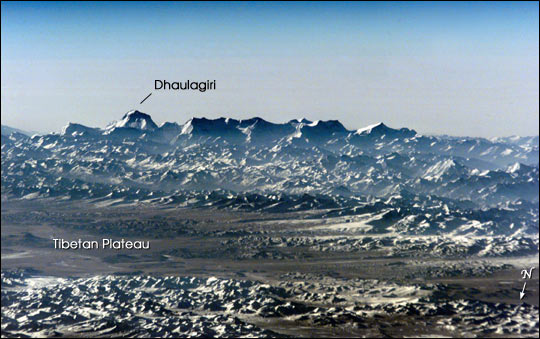 |
| Dhaulagiri, seventh-highest peak in the world (26,794 ft/8167 m), dominates the skyline in this image taken by the Expedition 1 crew from the International Space Station using a high-magnification lens. Although it looks like a view from a high-altitude airplane, the photograph was taken out of the window of the Space Station from an orbital altitude of 200 nautical miles (370 km). The view is southeastward across the southern Tibetan Plateau of China, to the Dhaulagiri Range of the Himalayas in central Nepal. The upper reaches of the more than 1,500-mile-long Brahmaputra River, which enters the Indian Ocean near Calcutta, are within the broad, high (about 17,000 ft) valley in the foreground. Uplift of the Himalayas continues today, at a rate of several millimeters per year, in response to the continuing collision of India with Eurasia that began about 70 million years ago. The region is home to hundreds of species of rare plants and animals, including the snow leopard and blue or Tibetan sheep. Dhaulagiri is a significant destination for trekkers and climbers -- the clear, dry days of autumn bring about half the yearly total of visitors. Expedition support, tourism, and agriculture employ much of the populace. |
| Images: | All Available Images Low-Resolution 55k |
|
| Mission: | ISS001 |
|
| Roll - Frame: | E - 6765 |
|
| Geographical Name: | NEPAL |
|
| Features: | PAN-DHAULAGIRI PEAK, HIMALAYA |
|
| Center Lat x Lon: | 28.5N x 83.0E |
|
| Film Exposure: | N=Normal exposure, U=Under exposed, O=Over exposed, F=out of Focus |
|
| Percentage of Cloud Cover-CLDP: | 10 |
|
| Camera:: | E2 |
|
| Camera Tilt: | HO | LO=Low Oblique, HO=High Oblique, NV=Near Vertical |
| Camera Focal Length: | 800 |
|
| Nadir to Photo Center Direction: | The direction from the nadir to the center point, N=North, S=South, E=East, W=West |
|
| Stereo?: | Y=Yes there is an adjacent picture of the same area, N=No there isn't |
|
| Orbit Number: | |
|
| Date: | 20010311 | YYYYMMDD |
| Time: | GMT HHMMSS |
|
| Nadir Lat: | N |
Latitude of suborbital point of spacecraft |
| Nadir Lon: | E |
Longitude of suborbital point of spacecraft |
| Sun Azimuth: | Clockwise angle in degrees from north to the sun measured at the nadir point |
|
| Space Craft Altitude: | nautical miles |
|
| Sun Elevation: | Angle in degrees between the horizon and the sun, measured at the nadir point |
|
| Land Views: | PLATEAU, RANGE, VALLEY |
|
| Water Views: | |
|
| Atmosphere Views: | |
|
| Man Made Views: | |
|
| City Views: | |
|
Photo is not associated with any sequences | ||
| NASA Home Page |
JSC Home Page |
JSC Digital Image Collection |
Earth Science & Remote Sensing |
|
This service is provided by the International Space Station program and the JSC Earth Science & Remote Sensing Unit, ARES Division, Exploration Integration Science Directorate.

|