
Geographic Region: BELIZE
Feature: CHETUMAL BAY
|
Geographic Region: BELIZE Feature: CHETUMAL BAY |
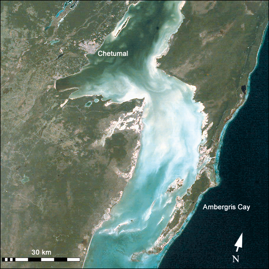 |
| ISS001-E-5317 Chetumal Bay, Ambergris Cay Chetumal Bay lies on the Border between Mexico and Belize. To the east of the bay, Ambergris Cay connects the Belize Barrier Reef to the Yucatan Peninsula. The north of the island is Bacalar Chico Marine Reserve. Here, the barrier reef comes very close to the east side of the island. In 1998, reefs in Belize were hit by two major events that led to heavy coral mortality: El Nino-related coral bleaching and Hurricane Mitch. Astronaut photographs of coral reefs are being used to provide perspective on coral reef geography, coastal development, and related land habitats. Numerous photographs taken by astronauts were included in the recently published World Atlas of Coral Reefs . Coral reef images acquired by astronauts can also be used as mapping data in more detailed remote sensing applications. Images of coral reef areas are being acquired by astronauts on Space Station Alpha as part of the Crew Earth Observations Project. Coral reefs are one of the areas selected as a scientific theme for this project (see also the recent Earth Observatory article, Mapping the Decline of Coral Reefs). |
| Images: | All Available Images Low-Resolution 351k |
|
| Mission: | ISS001 |
|
| Roll - Frame: | E - 5317 |
|
| Geographical Name: | BELIZE |
|
| Features: | CHETUMAL BAY |
|
| Center Lat x Lon: | 18.0N x 88W |
|
| Film Exposure: | N=Normal exposure, U=Under exposed, O=Over exposed, F=out of Focus |
|
| Percentage of Cloud Cover-CLDP: | 10 |
|
| Camera:: | E2 |
|
| Camera Tilt: | LO=Low Oblique, HO=High Oblique, NV=Near Vertical |
|
| Camera Focal Length: | |
|
| Nadir to Photo Center Direction: | The direction from the nadir to the center point, N=North, S=South, E=East, W=West |
|
| Stereo?: | Y=Yes there is an adjacent picture of the same area, N=No there isn't |
|
| Orbit Number: | |
|
| Date: | 20010123 | YYYYMMDD |
| Time: | GMT HHMMSS |
|
| Nadir Lat: | N |
Latitude of suborbital point of spacecraft |
| Nadir Lon: | E |
Longitude of suborbital point of spacecraft |
| Sun Azimuth: | Clockwise angle in degrees from north to the sun measured at the nadir point |
|
| Space Craft Altitude: | nautical miles |
|
| Sun Elevation: | Angle in degrees between the horizon and the sun, measured at the nadir point |
|
| Land Views: | ISLAND, PENINSULA |
|
| Water Views: | BAY, REEF |
|
| Atmosphere Views: | |
|
| Man Made Views: | |
|
| City Views: | BELIZE, CHETUMAL |
|
Photo is not associated with any sequences | ||
| NASA Home Page |
JSC Home Page |
JSC Digital Image Collection |
Earth Science & Remote Sensing |
|
This service is provided by the International Space Station program and the JSC Earth Science & Remote Sensing Unit, ARES Division, Exploration Integration Science Directorate.

|