
Geographic Region: MEXICO
Feature: POPOCATEPETL VOL., PLUME
|
Geographic Region: MEXICO Feature: POPOCATEPETL VOL., PLUME |
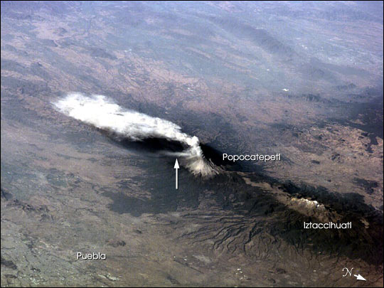 |
| Popocatepetl, or Popo, the active volcano located about 70 km southeast of Mexico City, sends a plume south on January 23, 2001. The astronaut crew on the International Space Station Alpha observed and recorded this image as they orbited to the northeast of the volcano. Popo has been frequently active for six years. On this day, the eruption plume reportedly rose to more than 9 km above sea level [for reference, Popo's summit elevation is 5426 m (17,800 feet)]. Note the smaller ash plume below the main plume (arrow). The perspective from the ISS allowed the astronauts this unique 3 dimensional view. Popo is situated between two large population centers: Mexico City (more than 18 million people, and just off the image to the right) and Puebla (about 1.2 million people). The region's dense population provides the potential for extreme impacts from volcanic hazards. Recent eruptions have been frequent, and have resulted in evacuations around the mountain. |
| Images: | All Available Images Low-Resolution 53k |
|
| Mission: | ISS001 |
|
| Roll - Frame: | E - 5316 |
|
| Geographical Name: | MEXICO |
|
| Features: | POPOCATEPETL VOL., PLUME |
|
| Center Lat x Lon: | 19.0N x 98.5W |
|
| Film Exposure: | N=Normal exposure, U=Under exposed, O=Over exposed, F=out of Focus |
|
| Percentage of Cloud Cover-CLDP: | 10 |
|
| Camera:: | E2 |
|
| Camera Tilt: | LO=Low Oblique, HO=High Oblique, NV=Near Vertical |
|
| Camera Focal Length: | |
|
| Nadir to Photo Center Direction: | The direction from the nadir to the center point, N=North, S=South, E=East, W=West |
|
| Stereo?: | Y=Yes there is an adjacent picture of the same area, N=No there isn't |
|
| Orbit Number: | |
|
| Date: | 20010123 | YYYYMMDD |
| Time: | GMT HHMMSS |
|
| Nadir Lat: | N |
Latitude of suborbital point of spacecraft |
| Nadir Lon: | E |
Longitude of suborbital point of spacecraft |
| Sun Azimuth: | Clockwise angle in degrees from north to the sun measured at the nadir point |
|
| Space Craft Altitude: | nautical miles |
|
| Sun Elevation: | Angle in degrees between the horizon and the sun, measured at the nadir point |
|
| Land Views: | MOUNTAIN, VOLCANO |
|
| Water Views: | |
|
| Atmosphere Views: | PLUME |
|
| Man Made Views: | |
|
| City Views: | PUEBLA |
|
Photo is not associated with any sequences | ||
| NASA Home Page |
JSC Home Page |
JSC Digital Image Collection |
Earth Science & Remote Sensing |
|
This service is provided by the International Space Station program and the JSC Earth Science & Remote Sensing Unit, ARES Division, Exploration Integration Science Directorate.

|