
Geographic Region: IRAQ
Feature: TIGRIS, AL HAWIZAH MARSH
|
Geographic Region: IRAQ Feature: TIGRIS, AL HAWIZAH MARSH |
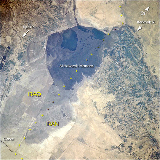 |
| The Al Hawizah Marshes comprise the largest remaining tract of wetlands in the Mesopotamian Marshlands of Iran and Iraq. In the last 10 years, damming and diversion of waters from the Tigris and Euphrates Rivers, and draining of wetlands has led to a loss of 85% of wetlands that once covered about 20,000 square km (7,725 square miles). This ecological disaster has been studied using Landsat data and summarized in a report by the United Nation Environment Programme's Division of Early Warning and Assessment, entitled The Mesopotamian Marshlands: Demise of an Ecosystem. [Print Resolution (13.3 MB)]. |
| Images: | All Available Images Low-Resolution 90k |
|
| Mission: | ISS001 |
|
| Roll - Frame: | 702 - 110 |
|
| Geographical Name: | IRAQ |
|
| Features: | TIGRIS, AL HAWIZAH MARSH |
|
| Center Lat x Lon: | 31.5N x 47.5E |
|
| Film Exposure: | N=Normal exposure, U=Under exposed, O=Over exposed, F=out of Focus |
|
| Percentage of Cloud Cover-CLDP: | 10 |
|
| Camera:: | HB |
|
| Camera Tilt: | HO | LO=Low Oblique, HO=High Oblique, NV=Near Vertical |
| Camera Focal Length: | 250 |
|
| Nadir to Photo Center Direction: | E | The direction from the nadir to the center point, N=North, S=South, E=East, W=West |
| Stereo?: | Y=Yes there is an adjacent picture of the same area, N=No there isn't |
|
| Orbit Number: | 1090 |
|
| Date: | 20010305 | YYYYMMDD |
| Time: | 124426 | GMT HHMMSS |
| Nadir Lat: | 50.9N |
Latitude of suborbital point of spacecraft |
| Nadir Lon: | .7E |
Longitude of suborbital point of spacecraft |
| Sun Azimuth: | 191 | Clockwise angle in degrees from north to the sun measured at the nadir point |
| Space Craft Altitude: | 201 | nautical miles |
| Sun Elevation: | 33 | Angle in degrees between the horizon and the sun, measured at the nadir point |
| Land Views: | |
|
| Water Views: | |
|
| Atmosphere Views: | |
|
| Man Made Views: | |
|
| City Views: | |
|
Photo is not associated with any sequences | ||
| NASA Home Page |
JSC Home Page |
JSC Digital Image Collection |
Earth Science & Remote Sensing |
|
This service is provided by the International Space Station program and the JSC Earth Science & Remote Sensing Unit, ARES Division, Exploration Integration Science Directorate.

|