
Geographic Region: USA-CALIFORNIA
Feature: SAN FRANCISCO
|
Geographic Region: USA-CALIFORNIA Feature: SAN FRANCISCO |
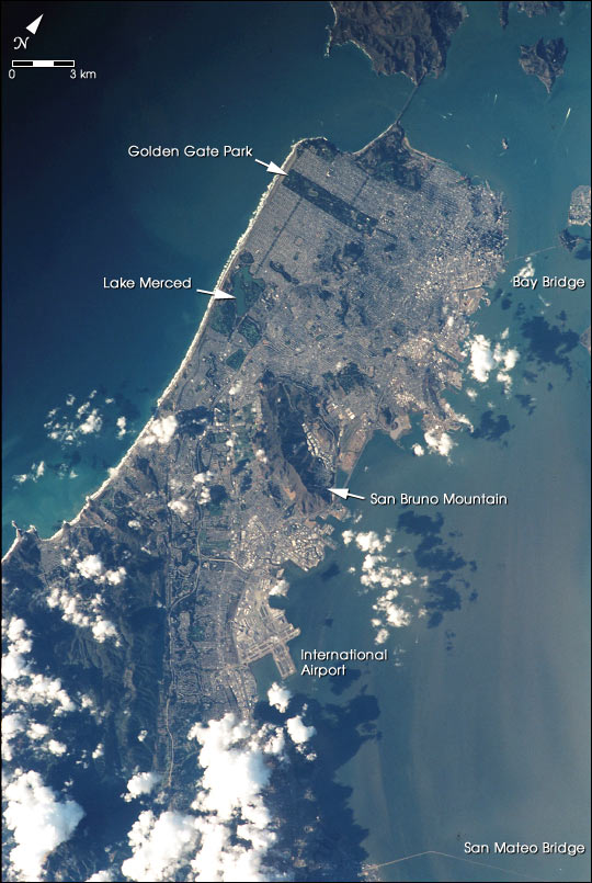 |
| This image shows a photograph of San Francisco taken as the International Space Station passed 383 km overhead on November 10, 2000. It was taken by astronauts looking out one of the station windows using 35 mm film and a 400 mm lens. The view includes the area stretching from the Golden Gate Bridge in the north to the San Mateo Bridge on the southeast. In the full-resolution version major landmarks are easily distinguished, and wider streets such as Van Ness and Geary can be easily distinguished from the less distinct grid of smaller streets. Digitized from film at high resolution, each pixel in this image represents 14.6 m on the ground. |
| Images: | All Available Images Low-Resolution 97k |
|
| Mission: | ISS001 |
|
| Roll - Frame: | 323 - 21 |
|
| Geographical Name: | USA-CALIFORNIA |
|
| Features: | SAN FRANCISCO |
|
| Center Lat x Lon: | 38.0N x 122.5W |
|
| Film Exposure: | N=Normal exposure, U=Under exposed, O=Over exposed, F=out of Focus |
|
| Percentage of Cloud Cover-CLDP: | 25 |
|
| Camera:: | NK |
|
| Camera Tilt: | LO=Low Oblique, HO=High Oblique, NV=Near Vertical |
|
| Camera Focal Length: | 400 |
|
| Nadir to Photo Center Direction: | The direction from the nadir to the center point, N=North, S=South, E=East, W=West |
|
| Stereo?: | Y=Yes there is an adjacent picture of the same area, N=No there isn't |
|
| Orbit Number: | |
|
| Date: | 20001110 | YYYYMMDD |
| Time: | 095159 | GMT HHMMSS |
| Nadir Lat: | N |
Latitude of suborbital point of spacecraft |
| Nadir Lon: | E |
Longitude of suborbital point of spacecraft |
| Sun Azimuth: | Clockwise angle in degrees from north to the sun measured at the nadir point |
|
| Space Craft Altitude: | nautical miles |
|
| Sun Elevation: | Angle in degrees between the horizon and the sun, measured at the nadir point |
|
| Land Views: | |
|
| Water Views: | |
|
| Atmosphere Views: | |
|
| Man Made Views: | BRIDGE |
|
| City Views: | SAN FRANCISCO |
|
Photo is not associated with any sequences | ||
| NASA Home Page |
JSC Home Page |
JSC Digital Image Collection |
Earth Science & Remote Sensing |
|
This service is provided by the International Space Station program and the JSC Earth Science & Remote Sensing Unit, ARES Division, Exploration Integration Science Directorate.

|