Geographic Region: CHAD
Feature: LAKE CHAD, WINDOW OBSTRUCTION
|
Geographic Region: CHAD Feature: LAKE CHAD, WINDOW OBSTRUCTION |
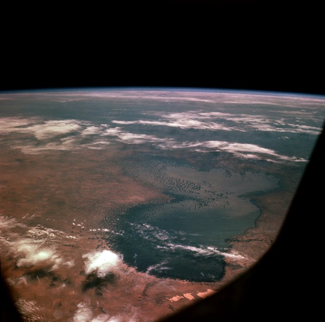 |
| AS07-8-1932 Lake Chad, Africa October 1968 The north and south basins of Lake Chad are visible in this southeast-looking, high-oblique photograph. The boundaries and depth of the lake fluctuate from season to season and year to year. Lake Chad is the 4th largest lake in Africa and the 17th largest lake in the world, covering an area of nearly 6000 square miles (16 000 square kilometers). The average depth of the lake in the north is only 10 feet (3 meters), whereas the average depth in the south is nearly 20 feet (6 meters). The lake is fed by two major rivers, the Chari and the Komadugu Gana, and by many lesser streams; but, it has no outlet. Lake Chad is a freshwater lake, which is very unusual for a desert lake. During periods of adequate rainfall, runoff accumulates in the basin, filling Lake Chad and permitting extensive agriculture and local fishing. Located on the southern boundary of the Sahara Desert, Lake Chad contains numerous sand dunes or islets in both its northern and its southern basin. Two million years ago, when the climate was much wetter, Lake Chad covered a large portion of the south-central Sahara Desert. As the climate became drier and some geologic uplifting occurred to the south of the lake, sending rivers that had been draining into the lake southward into the Congo Basin, the lake shrank to little more than 10 percent of its original size. Lake Chad continues to shrink because of droughts that plague that region of Africa. The northern basin, which is almost completely cut off from the southern basin by a ridge known as the Great Barrier, is especially vulnerable to any short-term changes resulting from drought conditions and excessive evaporation. The position of Lake Chad and the sensitivity of the lake to changes in regional rainfall make the site an ideal focus for drought impact studies using satellite data and astronaut photography. |
| Images: | All Available Images Low-Resolution 68k |
|
| Mission: | AS07 |
|
| Roll - Frame: | 8 - 1932 |
|
| Geographical Name: | CHAD |
|
| Features: | LAKE CHAD, WINDOW OBSTRUCTION |
|
| Center Lat x Lon: | 13.5N x 14.5E |
|
| Film Exposure: | N | N=Normal exposure, U=Under exposed, O=Over exposed, F=out of Focus |
| Percentage of Cloud Cover-CLDP: | 20 |
|
| Camera:: | HB |
|
| Camera Tilt: | LO=Low Oblique, HO=High Oblique, NV=Near Vertical |
|
| Camera Focal Length: | 80 |
|
| Nadir to Photo Center Direction: | The direction from the nadir to the center point, N=North, S=South, E=East, W=West |
|
| Stereo?: | N | Y=Yes there is an adjacent picture of the same area, N=No there isn't |
| Orbit Number: | |
|
| Date: | 196810__ | YYYYMMDD |
| Time: | GMT HHMMSS |
|
| Nadir Lat: | N |
Latitude of suborbital point of spacecraft |
| Nadir Lon: | E |
Longitude of suborbital point of spacecraft |
| Sun Azimuth: | Clockwise angle in degrees from north to the sun measured at the nadir point |
|
| Space Craft Altitude: | nautical miles |
|
| Sun Elevation: | Angle in degrees between the horizon and the sun, measured at the nadir point |
|
| Land Views: | BASIN, DESERT, PLAIN, DUNE |
|
| Water Views: | LAKE, DELTA, RIVER, SEA |
|
| Atmosphere Views: | |
|
| Man Made Views: | AGRICULTURE, PORT |
|
| City Views: | |
|
Associated Photos in Sequence:  Photo #: AS07-8-1932 ** Currently displayed photo ** Photo #: AS07-8-1932 ** Currently displayed photo ** Description: AFRICA, LAKE CHAD-1968--LAKE LEVELS BEFORE BEGINNING OF DROUGHT, 1970 Sequence ID: 3A  Photo #: STS052-99-9 Photo #: STS052-99-9Description: AFRICA, LAKE CHAD-1992--LAKE LEVELS FROM DROUGHT THAT BEGAN IN 1970 Sequence ID: 3B  Photo #: STS052-80-66 Photo #: STS052-80-66Description: AFRICA, LAKE CHAD-1992--LAKE LEVELS FROM DROUGHT THAT BEGAN IN 1970 Sequence ID: 3C  Photo #: STS061-75-22 Photo #: STS061-75-22Description: AFRICA, LAKE CHAD-1993--LAKE LEVELS FROM DROUGHT THAT BEGAN IN 1970 Sequence ID: 3D  Photo #: STS061-75-23 Photo #: STS061-75-23Description: AFRICA, LAKE CHAD-1993--LAKE LEVELS FROM DROUGHT THAT BEGAN IN 1970 Sequence ID: 3E | ||
| NASA Home Page |
JSC Home Page |
JSC Digital Image Collection |
Earth Science & Remote Sensing |
|
This service is provided by the International Space Station program and the JSC Earth Science & Remote Sensing Unit, ARES Division, Exploration Integration Science Directorate.

|